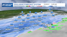
A cold front swept through the region Saturday night and ushered in much colder air, with temperatures starting out Sunday morning in the 20s south and single digits to teens north on this Super Bowl Sunday. It’ll remain mostly cloudy and dry across central and northern New England, with highs reaching the upper teens to low 20s, a great day to head to the mountains and do some skiing before the big game Sunday night.
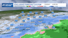
Across southern New England it’s a different story, as we find ourselves dealing with periods of light snow showers much of the day with steadier snow developing this afternoon and evening and continuing through the first half of the night across southeastern areas, including the Cape.

A developing low pressure system will pass east of New England along the frontal boundary which passed through the region last night with much of its precipitation remaining off shore but spinning enough back into New England to deliver a light to moderate snowfall Sunday into Monday.
Get New England news, weather forecasts and entertainment stories to your inbox. Sign up for NECN newsletters.

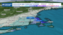
With temperatures in the upper 20s around the Boston metro area, we could see a few slick spots developing on some of the untreated surfaces Sunday morning into the afternoon, but we're not expecting much in the way of snowfall, about 1 to 3 inches is likely with lesser amounts to the north and west and a bit more possible Cape Ann.
It’ll be a different story south of Boston down toward the Cape, where we’ll see a bit of enhancement in the snow activity due to winds off the ocean. With temperatures in the low 30s for much of the day, the road conditions shouldn’t be too much of an issue, but take it slowly nevertheless, especially after sunset when we’re expecting temperatures to drop back into the upper 20s. This is also when we’re expecting periods of moderate snow to develop.

Snow will continue through about midnight and taper off toward sunrise Monday morning. About 3 to 5 inches is expected, with a few higher amounts possible if a bit more moisture gets involved. It's something we’ll be watching closely for you!
Weather Stories
Valentine’s Day on Monday is looking cold and blustery with high temperatures barely reaching the mid-20s south, mid to upper teens north. The cold air won’t last long as indicated on our exclusive 10-Day Forecast, as another warmup arrives by the middle of the week, with temperatures reaching the 50s again Thursday along with the chance for rain.


