A winter storm warning has been expanded to parts of New England.
That warning has expanded into part of the Berkshires and southern Vermont.
A wind advisory has been issued for coastal Connecticut, Rhode Island and the Cape and Islands. There could be wind gusts of 50 mph and power outages.
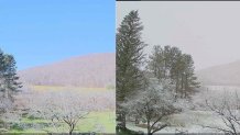
For a preview of what’s coming, check out this picture from Smethport, Pennsylvania:

The picture on the left was taken Friday afternoon; the one on the right was shot this afternoon. At 11 a.m., the temperature in Smethport was 60°; by 3 p.m., the temperature dropped to 32°.
We’re expecting this type of significant temperature drop Sunday. First we will see a round of showers. Showers will change to snow across the higher elevations of western New England before daybreak Sunday. Don’t expect a changeover to snow near the coast — precipitation will end before the temperature drop.
U.S. & World
As gusty winds develop out of the west northwest — the higher elevations will see significant upslope snow. When air is forced to rise over the mountains, it condenses, turns into clouds and then snow. Upslope snow is favorable through Monday evening (possibly even through Tuesday morning).
Total snowfall accumulations could reach 2 feet near Jay Peak; 8 or more inches throughout the Green Mountains and up to a half foot in the Berkshires.


