
Today marks day eight in a row of 90-plus degree temperatures in the Boston metro west and north region.
It should be the last consecutive day of 90-plus degrees, tying 2002 for the longest heat wave since necn launched in 1992.
It will be mostly sunny, hot and humid this afternoon with temperatures in the low to mid 90s.
A weak front in southern Canada will generate a few showers and thunderstorms in northern New England this afternoon and evening.
Clouds remain overnight, with a few showers, warm and humid, with low temperatures in the 70s.
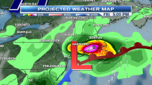
The weather pattern changes dramatically for our Friday.
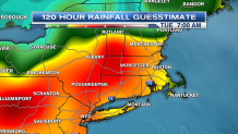
Low-pressure passing just south of New England will generate off-on rain for much of central and southern New England, perhaps greater than 1 to 2 inches of rainfall in some locations. Deep puddles may slow us down on the roadways.
Local


The possibility also exists for 3 to 5 inch amounts of rain somewhere between New York City and Boston. Localized flash flooding is not out of the question.
Wind tomorrow out of the Northeast will be gusting 25 mph near the shore, keeping temperatures in the 70s, the coolest weather in three weeks.
Temperatures near Boston may fall into the 60s during the afternoon, with fog developing.
Some of our heaviest rain storms occur when waves of low pressure form on warm fronts near the New England south coast.
That is what happens tomorrow, or more specifically we have a cold front stalling near the Massachusetts Turnpike, merging with a tropical (from the Gulf of Mexico) warm front over Long Island Sound. A 1007 millibar low will pass from New Jersey to Cape Cod Friday and Friday night.
Low-pressure races away on Saturday, leaving a mixture of sun and clouds and temperatures a little bit warmer, with highs back into the 80s with moderate humidity.
Saturday looks like a nice day for the beaches, fairs, and festivals.
Saturday night should be fair and seasonable with a low temperature in the 60s south, 50s north.
Clouds race back in on Sunday, with showers or even periods of rain developing from west to east during the afternoon. The high temperature will be close to 80 degrees.
Rain is likely on Sunday night and Monday morning, with temperatures holding in the 70s to low 80s.
The Sunday night rain may also add up to 2 inches, really helping out in our drought situation, which coincidentally is the worst since 2002, just like the heat wave.
Sunshine returns next Tuesday's temperatures back into the 80s, probably going back up to 90 degrees for the second half of next week before the next front arrives on Friday with more showers and storms.
