
The heaviest rain and wind will be on Sunday, but ahead of the main storm there will be enough moisture for periods of drizzle and freezing drizzle starting as early as Friday evening.
[CLICK HERE FOR THE LATEST WEATHER ALERTS.]
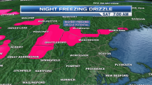
As temperatures drop after sunset and low level moisture saturates the air, we will start to see freezing drizzle across western southern New England and north. The best chance for icy conditions will be across most of Vermont, Central and Western New Hampshire and Southwestern Maine.
A thin glaze of ice may also form on some roads in western Massachusetts and Connecticut. If the temperature is below 32 degrees and you see moisture coming down, your best bet is to slow down and take it easy tonight and early tomorrow (watch your car thermometers).
Boston’s low should hover around 36 to 38, degrees so freezing rain is not a concern. On Saturday morning, there will still be some slick spots, but the temperature will steadily rise into the 40s.
Sunday, the big event unfolds with wind and driving rain. This storm has warm origins, so there is no concern for frozen precipitation.
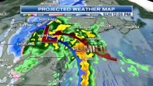
Highs will soar to near record levels across Southern New England. The record to beat is 56 in Boston and 53 in Worcester. We’ll be close to both of those values thanks to a howling south/southwest wind.
Local

Speaking of which, there is a surge of wind at about 1,000 feet up in the neighborhood of 60 to 70 mph.
[TRACK THE RAIN WITH LIVE INTERACTIVE RADAR.]
Hilly terrain and communities along the coast/capes will have the best chance to see their winds top out near 50 mph (not all of the wind will transport down to the surface). The fiercest wind will be through midday Sunday, translating down the Maine coast into the evening. Hold on tight!
Colder air will move in on Monday and Tuesday as the winds slowly settle down. Long range, the pattern will mellow, with seasonable temperatures.
