
Low pressure systems from both the Gulf of Mexico and Hudson Bay in Canada are heading right at New England this weekend. That means both heavy rain and heavy snow for our six-state region.
First, an arc of light snow from northern Vermont to southern Maine may coat the ground with an inch or two of snow by early Saturday. Then, heavy rain moves into Connecticut at dawn Saturday, rapidly expanding north and east for southern Vermont and southern New Hampshire, as well as all of Massachusetts, Connecticut and Rhode Island, by midday Saturday. Temperature are cold enough for a few hours of freezing rain in the upper Pioneer Valley to all of the Merrimack Valley. Rain is heaviest from noon to 6 p.m., when half an inch to an inch of rain may fall.
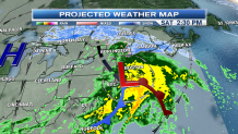
Rainfall, combined with melting snow, will cause deep puddles and possibly minor flooding of roadways, streams and basements. The mountains of northern Vermont, New Hampshire and most of Maine will experience snow for most of Saturday. Highs will be in the 30s north to low 40s south. Wind will be from the east 15-25 mph.
Precipitation will diminish to drizzle and fog south Saturday night, as snow continues in the mountains.
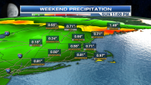
Sunday will be colder with rain changing to snow in from north to south. At the South Boston St. Patrick's Day Parade, we may have very large snowflakes for a few hours. The temperature should be warm enough that snow mostly melts on impact Sunday, with highs in the 30s.
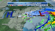
But in the mountains, and most of central and southern Maine, temperatures are cold enough for accumulation to continue. In Maine and many of the northern mountains, six to 12 inches of snowfall will accumulate. Parts of the Maine mid-cast area may have snow so heavy that branches break, causing scattered power outages.
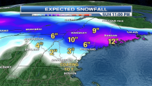
Highs Sunday will be in the 20s north and in the 30s south, with wind from the north 15-25 mph.
Local


Monday looks fair and seasonable, with highs from 35-45.
Another arctic front slides through New England Monday night and early Tuesday, with snow squalls and colder weather. Temperatures Tuesday will fall into the 30s south and 20s north, with wind from the northwest 15-25 mph.
Wednesday and Thursday look fair and cold, perhaps even with record lows near zero in colder locations Thursday morning. The mid-week looks fair with highs 28-38.
Another front from Canada brings cold and perhaps snow or rain again late next week into next weekend.
