
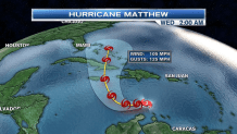
As of 11 a.m. Friday, the National Hurricane Center upgraded Hurricane Matthew from a Category 2 to a Major Hurricane - a Category 3 with maximum sustained winds of 115 mph and gusts up to 140 mph.
The latest update still shows Matthew continuing its track slightly westward through Saturday morning.
Midday Saturday is when Matthew – still as a Category 3 Hurricane – makes a turn northwest towards Jamaica, eastern Cuba, before advancing northward toward the Bahamas.
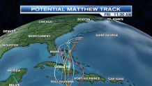
By early Tuesday, Matthew should already have passed over Jamaica and should be charging towards the Bahamas, but Matthew will lose steam after departing eastern Cuba, and should be downgraded to a Category 2 when it moves over the Bahamas overnight Tuesday into Wednesday.
The majority of the weather models bring Matthew up the eastern seaboard after the Bahamas, but the impacts we will see here in New England will be determined by the way the Jetstream (the river of fast winds in the atmosphere that steers weather systems) sets up as Matthew approaches the Mid-Atlantic.
As always, the necn weather team will keep you and your family updated with the very latest as we continue to keep our eye on Matthew. If anything, late next week is when we could possibly see some of the impacts related to Matthew.
The last time we’ve seen a major September Hurricane was last year around this time with Hurricane Joaquin on Sept. 28. Joaquin was a Category 4 at its peak.

![[NATL-MIA] Hurricane Matthew Weakens Slightly to Category 4 Storm in the Caribbean With 155 MPH Winds](https://ots.nbcwpshield.com/wp-content/uploads/2019/09/frozen-fish-MIA.jpg?fit=722%2C406)