
So how did that feel?
I'm talking about the arctic air. We had a little taste of what's to come Thursday night as lows dipped near zero in many spots across New England.
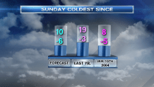
Nothing new, right? We've certainly been here before - especially last winter, when temperatures dipped as cold as -3 in Boston. But what's coming Saturday night and Sunday morning could be the coldest in over a decade!
Records May Fall
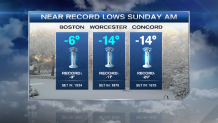
Low temperature records are in jeopardy in both Boston and Worcester on Sunday morning. The number to beat in Boston is -3, while in Worcester it's -11. And yes, these are just air temperatures. Wind chills - or what it feels like outside - will be MUCH colder. Wind chill warnings are up across most of New England for wind chills of 15 to 35 below zero. Coldest wind chills will be in the highest elevations across all of New England. Same with the coldest air temperatures. This represents a shift from our "normal" winter cold in that most often the coldest air "puddles" in the valley locations of New England on bitter nights.
It's All About Location
Local


This is a special kind of airmass. It's not often that we get an express delivery of arctic air from the North Pole. Most times, the air meanders and modifies a bit before it gets here. Not this time. Its origins in Siberia mean it will have a heavy, dense feel to it, with a penchant for drying out skin, hair and furniture, and creating incredible static. Also of note, batteries may fail and car tires may freeze across northern New England. Speaking of cars, everyone will receive poorer gas mileage due to the fact that your vehicle has to "plow" through much denser air. Think of it as if you're driving through cream vs. water.
Timing
The front will cross first thing Saturday morning, but the most numbing air will slowly roll in throughout the afternoon. High temperatures will be in the teens in the morning, then crumble through the afternoon. As the cold moves in, a storm will form offshore, clip Cape Cod in the morning, then focus a band of intense snow in Downeast Maine for the afternoon.
The cold will soften a bit on Sunday afternoon - along with the winds (mercifully) and then push offshore Sunday night and early Monday. Nonetheless, highs struggle to make it to 10 on Sunday afternoon.
Next Up
A rainstorm? Yep. There might be a brief mix (or snow) Monday night, but gusty winds from the southeast ensure that the rain will take over into Tuesday. Highs soar into the 40s by Tuesday and Wednesday as we thaw out. Another shot of cold will come in by Thursday, but it won't be nearly as bitter.
Be safe, stay warm, keep hydrated and check on your neighbors this weekend.
