
Corsicana, Texas, experienced severe flooding due to a stalled front, and 20 inches of rain fell 72 hours Thursday through Saturday. Rain moved south to the Texas coast Saturday and Sunday, when Houston received more than seven inches of rain.
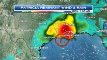
Contributing energy to the stalled front is the remnant of Hurricane Patricia. Patricia came onshore in Mexico as a rapidly weakening storm over a sparsely populated coastline early Friday night.
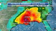
By Saturday night, the old circulation reached the Gulf of Mexico on regenerated to a non tropical cyclone generating wind gusts past 50 mph along the Texas and Louisiana shore Sunday and Sunday night. That storm center is moving only very slowly now, bad news for Louisiana with the threat of flooding and tornadoes through Monday. Then, the storm starts moving northward and will have some impact on New England.
Here in the northeast, though, we start the week cool and dry.
High pressure from Canada brings us sunshine on Monday, after a frosty start we warm to the lower 50s with the breeze from the Northwest.
Local


There will be another frosty start Tuesday, with sunshine and temperatures again in the low to mid 50s.
Then, the remnant of Hurricane Patricia advances to the northeast on Wednesday.
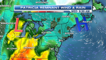
New England starts off dry, but rain will be heavy by Wednesday evening. High pressure to our east, combined with low pressure to the west, will generate a gale force winds for a short time late Wednesday and Wednesday night. The wind direction will be from the east then southeast, combined with the highest tides of the month, may result in minor coastal flooding and erosion.
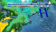
A bit of drier air should work in on Thursday, any sunny breaks will get us into the 60s.
Then, another cold front from Canada Thursday night brings some mountain snow showers and a brisk mix of sun and clouds for our Friday.
The weekend looks cool and dry.
