
Above: Take a look at the Weather Warrior live feed.
A quick-hitting snowstorm is impacting southern New England on Friday.
We are looking at a dusting to an inch north of the Mass Pike, around 2 inches across the Boston-Metro area, 3 to 4 inches across Rhode Island to the Plymouth-Taunton corridor and up to 6 inches across the Cape and Islands.
Snow showers fall across Vermont and New Hampshire on Friday. The highs across New England will range from the mid-30s south to mid to upper 20s north. Snow showers may develop across the North Shore on Friday night, eventually shifting south to the Outer Cape. These snow showers may produce an additional inch or so.
An arctic cold front ushers in gusty winds and a much colder air mass on Friday night.
Lows will range from the single digits across the North Country to the teens across the coastal plain. Wind chills plummet to below zero Saturday morning as cold air and gusty winds continue to stream into the region.
Highs on Saturday only reach into the low 20s south and single digits north. These low temperatures will tie or break previously-set records across New England.
Local


Back in 1874, Boston set a record lowest high temperature of 22 degrees and in 1874, Concord, New Hampshire set a record lowest high temperature of 18 degrees. Burlington, Vermont’s record lowest high temperature is 14 degrees, set back in 1885.
Strong winds will continue as the region becomes sandwiched between an approaching high from Canada and the departing coastal low over the Canadian Maritimes.
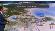
Winds may gust 35 to 40 miles an hour at times during the day on Saturday under partly cloudy skies. Lows on Saturday night could drop into possible record-breaking territory in the single digits at the coasts and below zero across the north.
The chilly air mass remains overhead on Sunday with sunny skies and cold temperatures remaining as the predominant features. Highs on Sunday moderate slightly into the mid-20s south and mid-teens north. Record lowest high temperature records may be in jeopardy again on Sunday.
The start of the work week will feature continued sun with temperatures further moderating into the low 30s south to low 20s across the North Country.
We are continuing to monitor the potential for an impactful snowstorm across southern New England Tuesday into Wednesday.
Where the heaviest snow will fall and how much remains unknown at this time. Strong winds and high seas may become impactful during this storm along the coast.
Behind this storm, we are expecting an area of high pressure to sweep across the region, ushering in temperatures that are close to the climatological average for mid-March.
Stay with your Early Warning Weather team for the latest weather updates.
