
Typical winter day across New England: some cold, some peeks of sun, and quite a bit of gray.
What we missed is noteworthy too. A potent storm system darted offshore with heavy snow on one side and thunderstorms on the other. It's a sign of the times - lots of energy remains in the jet stream overhead.
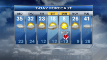
Next weather system is a LOT weaker. It doesn't even have the gumption to consolidate the snow showers like today's weather system. As a result, when it comes through tomorrow, I'm seeing off and on snow showers. Admittedly, some snow may be steady or even moderate for a brief time, but with temps in the mid 30s, it won't accumulate efficiently. All told, it's a blanket coating to 2 inch forecast for all of New England. Many will come away with nothing more than a few flakes.
Bitter Air in Route
Then we brace for the cold. A small but numbing chunk of cold will break from the North Pole - literally an extension of the Polar Vortex - and plunge into the Northeast this weekend. It comes with a few flakes and a wind shift on Saturday and won't leave until Monday morning. This air is every bit of dangerous too. Coupled with the wind, it may feel as cold as 20-30 below by Sunday morning! If we remain in the single digits on Sunday, it's likely that this will be the coldest air since 2004 to strike Greater Boston.
Then it bounces out as quickly as it came in. In fact, we are eyeing the prospect of rain in Southern New England by Tuesday as another weather system moves into New England.
Local


Pete
