
Two months ago, we set a record with 40 inches of snow in the necn yard.
Now, it's almost gone.

We are really turning a corner from winter to spring this weekend.
It's not a minute to soon. There has been snow and ice falling from the sky just about every day for the last three weeks. At the snow stake on Mount Mansfield, the depth reached 90 inches on Thursday, April 9, the most of the winter. Ice on our local lakes in southern New England is finally disappearing. In fact, there is even record keeping on "ice-out" dates kept at Blue Hill Observatory (and many lakes in the northwest).
Brian Fitzgerald at Blue Hill posted this statistic Friday:
1:00 PM EST UPDATE: Both Houghton's and Ponkapoag ponds were temporarily
visible late this morning, with between 10-20% coverage on Houghton's
Pond, and 40-50% ice coverage on Ponkapoag. Further inspections
will take place later this afternoon and tomorrow morning.
Latest Houghton's Pond Thaw Date, (1886-2015)
1) April 14, 1926
2) April 10, 1887
April 10, 1888
4) April 9, 1923
5) April 8, 1993
6) April 7, 1899
April 7, 1956
8) April 6, 1916
April 6, 1917
April 6, 1924
April 6, 1940
12) April 5, 1895
April 5, 1920
April 5, 1941
April 5, 1969
April 5, 1994
17) April 4, 1904
April 4, 1906
April 4, 1967
April 4, 2001
21) April 3, 1892
Latest Ponkapoag Pond Thaw Date, (1886-2015)
1) April 10, 1926
2) April 9, 1923
3) April 6, 1940
4) April 5, 1916
April 5, 1924
6) April 4, 1967
April 4, 1994
8) April 3, 1904
April 3, 1920
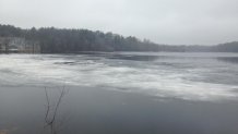
On the way to neck on Friday, I took this photo of Jacobs Pond in Norwell, Massachusetts. It looks like ice-out there is imminent, so I am calling it out now. This is the latest ice-out since I have been keeping track, beating April 8, 1993.


The weather system responsible for violent weather and tornadoes in the Midwest has passed north of New England. Its attendant fronts brought a few showers and a thunderstorm or two, along with much warmer air.
High pressure builds over the Great Lakes to the Mid-Atlantic states for the weekend. This means warmer wind from the west, and then southwest. (though the highest mountains are a bit wintry early Saturday). Highs Saturday in the 50s are seasonable. Highs Sunday and Monday warm above normal, into the 60s, even some low 70s by Monday.
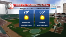
Opening Day at Fenway Park looks great, with sunshine near 70 degrees.
A week front with showers crosses New England Tuesday night. Then, more mild air and sunshine should be back Tuesday afternoon, through the end of next week.
A wet windy storm will be approaching next weekend. But it looks more wet than white. We can not state that snow is done here just yet. But the next several days represent a new weather pattern, the warmest since the few days before Halloween of last year.
