
The slow-moving storm system to our Northeast that brought the wind, the chill, and the mountain snows for the last several days is finally pulling out.
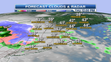
That leaves us with a bright day, especially in western and southern New England with more sun and clouds. Snow showers continue in parts of eastern Maine. High temperatures today in the 30s in the high country to 40s and near 50° as we move south and west. Wind from the northwest will relax to 10 to 15 mph this afternoon.
Mostly clear sky tonight with a low temperature in the 20s to low 30s, widespread frost likely.
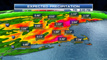
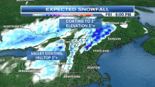
A fast-moving low-pressure system that raced from the Pacific ocean to the Midwest, is rushing into New England tomorrow. We have some sunshine early, but rain and snow is developing during the afternoon. Any snow should accumulate only in the higher elevations of Northwest Connecticut, the Berkshires in Massachusetts, in the mountains of Vermont. Otherwise rain is expected to arrive on the eastern shores by three in the afternoon, high temperatures tomorrow in the 30s to mid 40s.


Rain and elevation snow will overspread all of New England as the sun goes down tomorrow. Precipitation will be heavy at times overnight. Rainfall amounts exceeding 1 inch are likely before rain tapers to showers just after sunrise Friday in southern New England.
Snowfall amounts in the high terrain of New Hampshire and Maine in the order of 5 to 10 inches.
Wind on Friday will be gusting 40 to 50 miles an hour from the southeast, then northwest, along the coast from Cape Cod to Maine.


For most of Western and southern New England Friday should become sunny with a high temperature close to 50°.
Local


Another fast-moving system will move through New England over the weekend with the period of rain late Saturday and Saturday night, again mixed with some snow in the highest elevations in northern New England.
Temperatures should be a little warmer with highs getting into the 50s.
Rainfall amounts look to be lighter, less than a quarter inch for most of us, and most of it should fall late Saturday ending before sunrise Sunday.
Though Sunday clouds and showers may linger in southern New England, high in the 50s.
The Halloween outlook is fair and seasonable, about 50 degrees for Trick or Treat time.
