Windy weather of the last few days is calming down as low pressure moves away and high-pressure moves in.
And though our air is still coming from Canada, it has warmed up in Canada, so we warm up in New England.
The exception can be right at the beach, as lighter wind this time of year mean localized seabreezes.

The net result is mostly sunny skies for our Wednesday, with a high temperature in the low 80s Inland and 70s right at the shore.
Sunburn factor is very high, as we approach the solstice.. this is the strongest sunshine of the year.
Meteorologist Matt Noyes' Pics of the Day
Local
We are watching low-pressure to the west of New England that gets a little closer for our Thursday, so the sun isn't quite as bright, we will have a mixture of sun and mid to high level cloudiness in southern New England tomorrow.
The old low-pressure system that brought the cooler wind earlier in the week, is going to make one more attempt to bring us a few showers on Friday.
A week trough will rotate in from southeastern Canada bringing many clouds Friday and some scattered showers, primarily away from the shore.
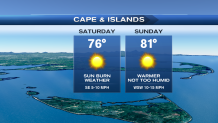
High-pressure rebuilds in here for the weekend, setting up a Chamber of Commerce type weather forecast.
Both Saturday and Sunday features an almost cloud-free sky, temperatures well into the 80s inland, with a comfortable seabreeze, keeping high temperatures in the 70s at the beach.
And because this warm air is coming from Canada, it means relatively low humidity.
The next weather front approaches Monday night and Tuesday, with it the air is still warm in the 80s to near 90. But we bring in the chance for shower in a thunderstorm later Monday and Tuesday.
There are some signs that that front may stall near the south coast of New England the next week, if that happens we could end up with a bit of rain, which we are really starting to need as it's been so dry lately.
But for the time being we are just going to enjoy this long stretch of fine New England summer weather.


