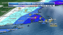
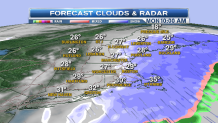
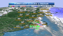
Our spring snowstorm hits hardest in southeastern Massachusetts and Southeastern Maine today.
Snowfall rates of 1/2 to 1 inch per hour continue through mid-morning.

As the sun gets higher in the sky we see less accumulation on roadways, but the plows are out in many locations and it is a thick pasty snow.
The weight of the snow on tree branches may result in a few powerlines being interfered with, with scattered power outages possible.

By afternoon we get breaks of sunshine, but a few more fairly heavy showers of snow and/or rain this afternoon.
Local
Those sunny breaks and temperatures near 40 means roads should be mostly wet for the evening commute.
As of sunrise, and intensifying low-pressure system is passing 50 to 100 miles southeast of Nantucket. This is a spring time nor'easter.

But, because the storm is only in it's developmental stages at this point, we are not expecting any serious problems at the ocean.
Mid and late morning high tides will result in some minor to moderate coastal erosion, but flooding is not expected.
Wind on Cape Cod in the islands could gust past 35 mph from the north this morning and early afternoon.
[CLICK HERE FOR SCHOOL CLOSINGS]
Seas our building 5 to 10 feet, with more of an off shore wind later in the day.
We should have a pretty bright near full worm moon tonight, with low temperature in the 20s. Side roads and sidewalks could become a little slippery with a refreeze.
[CLICK HERE FOR INTERACTIVE MAPS AND RADAR]
Tomorrow morning will be cold and breezy with temperatures climbing through the 30s, but by afternoon we are in the 40s with rapidly melting snow.
Later in the week we do see the potential for some more mixed rain and snow, first in the mountains tomorrow night, then again Wednesday night and Thursday.
Will have more on that after we clean up with this storm.


