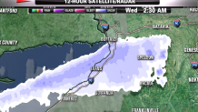
Buffalo, New York, is no stranger to lake-effect snow, but the snow, which has fallen just outside the city, has been astonishing and overwhelming.
Blinding snow falling at the rate of 3-5 inches per hour has stranded motorists in their cars and people in their homes with drifts as much as 6-7 feet high.
So how did this happen?

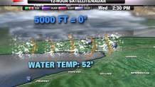
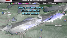
Lake-effect snow is caused when a very cold air flows directly over the warmer waters of a long large lake, such as Lake Erie. This is called a fetch. Intense evaporation adds water vapor into the clouds. The Arctic cold quickly condenses this vapor to snow which falls to the ground. The warmer the lake and the colder the air, the greater the rate of evaporation, and so the greater chances of heavy snow.

November is known as the month for lake-effect snow outbreaks. Despite being forecasted well in advance, the atmospheric environment was ripe for a heavy historic snowfall.
Local
What is so interesting about lake-effect snow is a distance of only a few miles can make the difference between whiteout conditions and or just a few flurries.
Meanwhile, in the small town of Cheektowag, they are digging out of 65 inches of snow, while just on the other side of town, only 2 inches had been measured
With another round of snow to come, the National Weather Service says this week’s totals will undoubtedly rival or exceed the all-time snowfall record for Buffalo, which is 81.6 inches over the course of five days in 2001.

Can this happen here? The answer is a resounding no. Our lakes are simply not big enough. But sometimes, we do get a cold wind off the warmer ocean, which can create "ocean-effect" snow. This can come with locally enhanced bands of heavy snow and produce a quick 1-2 feet.
But 6 or 7 feet? Not a chance; they call western New York the snowbelt for a reason.


