
We’re on the eve of the big storm. It’s been making headlines across the country for a couple of days now. Everything from extreme temp drops – from 51 to 0 in Denver – to blizzard-like conditions near the Twin Cities.
Extreme cold won’t be the headliner here. However, we’ve definitely seen worse in that respect. However, we WILL get a dose of wind and rain along with the crashing temperatures.
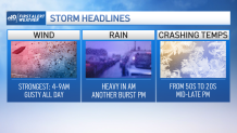
It all starts unfolding (unraveling) tonight as the main batch of rain moves our way after 8pm. Heavy rain moves in closer to 4am, with the potential for a rumble of thunder until 8/9am. This is the most intense part of the storm in terms of rain and wind.
Get New England news, weather forecasts and entertainment stories to your inbox. Sign up for NECN newsletters.
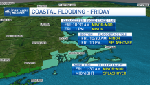
Gusts coming off the water from the southeast could be as high as 60 mph along the coast. Gusts elsewhere will be as high as 45-50 in that timeframe. Then the winds will ease, the rain will turn to sprinkles as we await the second phase of the storm in the afternoon.
Between 3-5pm the wind will pick up again and a line of heavy rain will move through. This is the cold front and it signals the arrival of the arctic air. Before it gets here, we’ll jump into the upper 50s with a bit of humidity too.
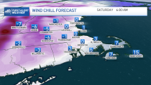
After it leaves, our temps will be in freefall. We will drop through the 40s, the 30s and into the 20s within 3-4 hours. That’s obviously not enough time for the roads to dry out, so there may be some icy spots…in addition to any standing water freezing. Gusty winds will continue into Saturday morning as the cold air continues to funnel in.
Christmas Eve and Christmas Day look identical. Blustery, cold, dry. Highs struggle to make the mid/upper 20s. While that’s cold, it’s not as cold as other parts of the country. Nor is it that cold for our standards in New England. Either way, Santa will need to layer up this year as he makes the rounds.
Travel safe in the coming days. We’ll keep you posted on the latest storm details here, on social media and on air.
