
There’s a noticeable change in the air Friday. Temperatures are running 10 to 20 degrees colder for most of us than this time on Thursday.
Added to that, a brisk breeze out of the west-northwest gusting to 35 mph and perhaps even 40 mph will certainly make it feel chilly.
Friday night, the wind will gradually ease and the skies will be clear, allowing temperatures to drop into the 20s for many of us and the low 30s in Boston --making it the coldest morning so far of the season for the city.
Get New England news, weather forecasts and entertainment stories to your inbox. Sign up for NECN newsletters.
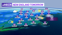
Ample sunshine is in the forecast Satrday, and the wind won’t be as active, so it will definitely feel a little better if you are going to be outside. Highs will be in the 40s, slightly below average for this time of year.
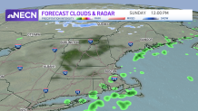
Clouds will advance into the region Saturday evening, meaning Sunday will be mostly cloudy aside from a few breaks here and there. A lot of Sunday will be dry. There is a chance of a few showers, particularly in southeast Massachusetts and far western New England late in the day.
The steadier rain arrives Sunday night into Monday, slowing travel somewhat but not creating significant headaches in the weather department.
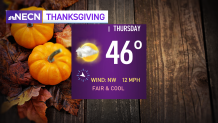
Chilly air returns on Tuesday and Wednesday, with a slight moderation in temperatures back to near 50 on Thanksgiving. A few quick moving disturbances will bring the risk of some showers heading into next weekend as seen in our exclusive 10-day forecast.
