
It’s a bright and beautiful looking day across the region, but our sunshine will be ineffective Tuesday.
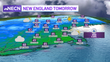
While we won’t be breaking record cold high temperatures like Monday, our highs will be running below average and the wind is still active out there. Gusts of 20 to 30 mph mean there will be a nip to the air; wind chill values will be running in the teens and 20s from north to south.
Wednesday is our transition day. We’ll start with sun and end up with increasing clouds as the wind shifts to blow out of the southwest and allows our temperatures to climb into the 40s. A warm front will slide through the region Wednesday night, accompanied by a few light mixed showers, particularly in western and northern New England.
Get New England news, weather forecasts and entertainment stories to your inbox. Sign up for NECN newsletters.
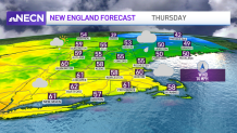
By Thursday, we’ll be on the warm side of the front and our highs will top out in the 50s and even some lower 60s. In exchange for the mild air, we will be dodging some raindrops, but it does not look like a washout by any means. Certainly a day to keep the umbrella on standby, though.
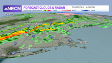
The heaviest rain will push through the northern half of New England Thursday evening and night; I anticipate some locally heavy downpours and perhaps even a few rumbles of thunder. Early morning rain on Friday will depart, giving way to breaks of sun, highs around 60 and a few additional showers later in the afternoon.
Those showers are part of a cold front that will knock our temperatures back down a bit for the weekend. Our exclusive 10-day forecast shows above normal temperatures next week with the greatest threat for rain on Wednesday into Thursday.
