
Low temperatures Monday morning in the single numbers and teens fell just short of the records set on March 15, 1993. That was a long winter -- we had ice on the ponds in southern New England until April. This cold blast is going to only slowly ease over the next 48 hours.
It’s a combination of the arctic front that passed Sunday turning into an ocean storm Monday, along with a huge, strong high-pressure system centered over the Great Lakes, responsible for wind continuing to gust past 30 mph. The thermometer recovers to about freezing near the south coast, to the low 20s in northern New England, but this wind will keep the chill factor in the single numbers in teens.

Wind will slowly diminish overnight, with mostly clear sky, low temperature in the single numbers and teens north and teens and 20s south.
Get New England news, weather forecasts and entertainment stories to your inbox. Sign up for NECN newsletters.
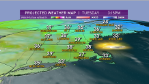
The high-pressure system goes right over us Tuesday, so after a cold start, we should get back to about 40 degrees in southern New England Tuesday afternoon and much less wind.
The storm that caused the severe weather in the south and the blizzard in the Central Plains is expanding and weakening. We may get clipped by a decaying snow band in Connecticut Tuesday evening.
Some flurries are possible in parts of Massachusetts and Rhode Island also. But for the most part, the system is going to stay well to the south, so our St. Patrick’s Day turns into a mix of sun and clouds. A few rain or snow showers are possible in northern New England due to a separate front coming in from Canada.
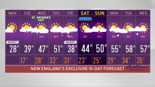
It’s a very low confidence forecast for the middle and second half of the week. Waves of low pressure are rippling along the boundary between the cold air and southern Canada and warmer air trying to come from the south into New England. It looks like we do get back to 50 degrees in spots by Thursday.
U.S. & World


Then another storm is going to be coming out of the deep south, where a major severe weather outbreak is likely this week. That storm may get up to the south coast of New England on Thursday night, with a chance of rain developing. But new cold air will be arriving and the rain may change to snow with a possibility of a nor’easter on Friday.
It will be a storm at sea, and how close it gets is a really tough call. Stay tuned to our First Alert 10-day forecast for the latest updates.
