
Clouds have been hanging around all day long after showers lingered on Cape Cod and the Islands for most of Monday afternoon. Temperatures slowly fall as a gusty west-northeast wind ushers in the changing air.
Monday night, our lows tumble into the 20s and low 30s as the sky clears. A few flurries linger in the mountains.
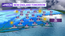
Highs Tuesday struggle to reach the 40 degree mark as colder air grips the northeast.
Get New England news, weather forecasts and entertainment stories to your inbox. Sign up for NECN newsletters.
The good news is that our weather pattern remains quiet through Thanksgiving. We can certainly deal with the cold as long as it’s quiet and nice travel weather. The only issue would be flight delays in the Midwest or northeast through Wednesday due to gusty winds.
Tuesday night will be even colder as the winds relax and temperatures fall to the teens and 20s. Ocean effect snow showers are likely across the outer Cape and Islands with the northwest flow and colder air moving over the relatively warmer water. Little to no accumulation is expected.
We stay below normal through most of the 10-day forecast. Thanksgiving happens to be the mildest day, with highs in the low 50s.

Our next system heads in Friday and will bring rain and snow to the northeast. Snow will be confined to higher elevations in northern New England, with rain for Boston, Hartford, and Providence. Several inches of snow is forecast across ski areas through Saturday.
U.S. & World


We turn cooler again with highs in the low 40s both days this weekend and we’re dry both days. The cool air hangs around for the rest of the 10-day too.
