
We have beautiful fall weather to soak up across the region Friday afternoon before a noticeable change moves in. We’ll enjoy lots of sunshine and highs in the upper 60s and lower 70s.
A backdoor front sliding down through the coast of Maine and New Hampshire seacoast will continue to push westward over the course of Friday evening.
When it comes through, you’ll know it. A sharp wind shift and low clouds will accompany this boundary, and a few sprinkles and showers are likely too.
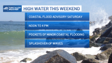
We’ll be positioned on the cooler side of this front on Saturday, so high temperatures will only be around 60 for many, with many clouds and a sprinkle or two possible. Also of note, our tides are astronomically high. That combined with an onshore wind will mean the risk of minor coastal flooding and splashover at vulnerable spots at the shoreline either side of high tide on Saturday.
Get New England news, weather forecasts and entertainment stories to your inbox. Sign up for NECN newsletters.
Sunday, we’ll moderate the temperature a little bit; highs will climb into the middle 60s under mostly cloudy skies. The chance of showers increases by Sunday evening and night across southern New England, with a developing storm to our south. The center of it should stay far enough away that the bulk of the rain will miss us too.

Aside from a few lingering showers early Marathon Monday morning -- the greatest chance along the south coast to Cape Cod -- our day should be dry, with highs nearing 70.
U.S. & World


Next week’s weather pattern is fairly quiet, with minimal shower chances and highs back in the 70s Tuesday and Wednesday.
