
A historic blizzard descended upon us Saturday.
As the storm finally starts to wind down, the National Weather Service Boston has made it official, saying blizzard conditions were met in several areas across southern New England, including Boston, Worcester, Hyannis and Martha's Vineyard in Massachusetts, and Providence, Newport, and Block Island in Rhode Island.
The National Weather Service considers a storm a blizzard if it has snowfall or blowing snow, as well as winds of at least 35 mph that reduce visibility to a quarter-mile or less for at least three hours. In many areas, Saturday's storm met those criteria.
Get New England news, weather forecasts and entertainment stories to your inbox. Sign up for NECN newsletters.
The nor'easter with hurricane-force wind gusts battered much of the East Coast on Saturday, flinging heavy snow that made travel treacherous or impossible, flooding coastlines, and threatening to leave bitter cold in its wake.
Rhode Island, all of which was under a blizzard warning, banned all nonemergency road travel. In West Hartford, Connecticut, a tractor-trailer jackknifed on Interstate 84, closing several lanes. Massachusetts banned heavy trucks from interstate highways.
The storm thrashed parts of 10 states, with blizzard warnings that stretched from Virginia to Maine.
Boston was in the crosshairs, and the city could get more than 2 feet of snow by the time it moves out early Sunday. Winds gusted as high as 83 mph on Cape Cod in Massachusetts. Forecasters watched closely for new snowfall records, especially in Boston. The Boston area's modern snowfall record is 27.6 inches, set in 2003.
How much snow will we get?
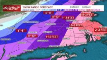
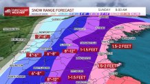
A widespread 18 to 28 inches of snow was forecast for Boston, Providence, the New Hampshire coast to Portland, Maine, and the upper Cape. We'll see 10 to 18 inches on the outer Cape and Nantucket with more mixing, and 10 to 18 inches in western Massachusetts and Hartford, Connecticut, with totals dropping off quickly west of there to 2 to 4 inches in the Berkshires.
The snow has been fast and furious throughout the day, making travel dangerous.
The snow has continued to pick up in waves of intensity. Plow trucks have had a hard time keeping up with the rapid snowfall rates of 1 to 2 inches plus per hour and at times in eastern New England in the most intense snow bands, 2 to 4 inches per hour.
Visibility will be near zero and the snow will be blowing and drifting with the fluffy consistency. The snow remains heavy until Saturday evening, wrapping up west to east rapidly by dinnertime.
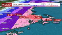
In the heaviest snow bands, we will see over 30 inches of snow. That could set up over areas just northwest of Boston to the Merrimack Valley as well as the South Shore. This set up may give one community 18 inches, and another 30 inches in a 5-mile stretch. Thundersnow is also likely with these intense bands.
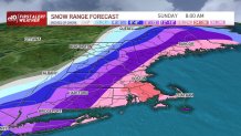
For reference, here are the Top 5 biggest Boston snowstorms (2 day total): Top spot is February 17-18, 2002 with 27.6 inches; February 6-7, 1978 with 27.1 inches; April 1-2, 1997 with 25.4 inches; February 8-9, 2013 with 24.9 inches; and 5th place is January 26-27, 2015 with 24.4 inches.
How widespread will power outages be in Massachusetts?
Gusts from the northeast will push 40 to 50 mph along routes 128, 495, to Worcester. Thirty to 40 mph gusts across Springfield and Vermont to interior New Hampshire. At the coast of Maine, New Hampshire, and all of eastern Massachusetts to southern Rhode Island we will see gusts of 50 to 70 mph or greater in isolated spots.
In fact, with gravity waves that are expected to spread out from the storm center, this could carry more intense wind to the coast, so the outer Cape, South Shore to the tip of Cape Ann may gust to 80 mph. This will contribute to tree damage, shingles off roofs, and power outages. Those without power will have another serious problem with the bitter cold after the storm. Temperatures will stay below freezing through Monday afternoon. Lows will be in the teens Saturday night and Sunday night, and highs in the mid 20s Sunday.
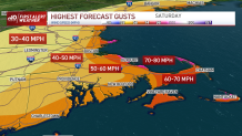
As of 2 p.m. wind gusts had reached 99 mph in Truro and several towns had seen gusts in the 80s and high 70s.
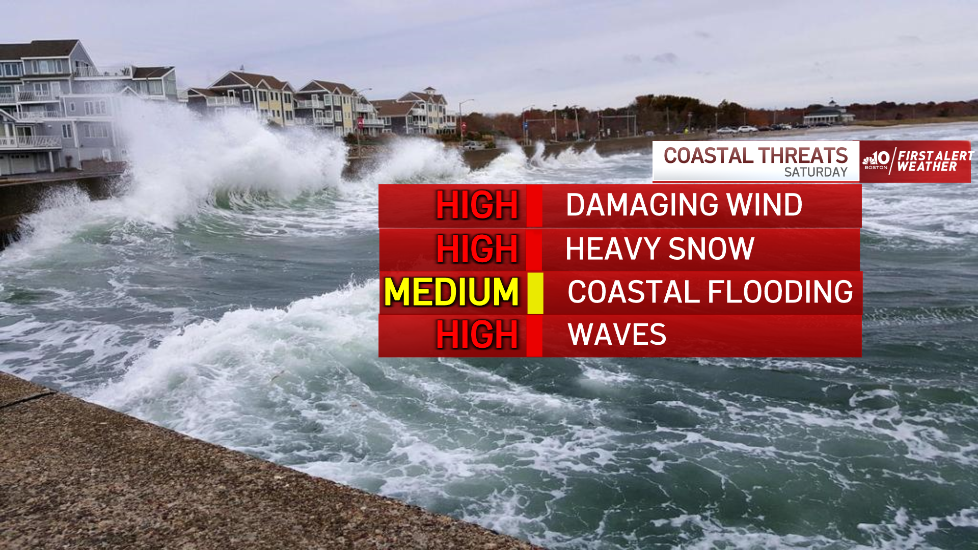
How concerned should we be about coastal flooding?
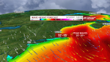
Our tides are running astronomically higher due to the new moon. A storm surge of 1 to 3 feet is forecast, with the high tides at 9 p.m., and on Sunday morning.
Our waves were 10 to 15 feet with a northeast wind during Saturday morning’s high tide, which led to some minor flooding. Waves will increase to 20 to 30 feet offshore with a northeast-north wind during the evening high tide, which will cause some minor to moderate flooding.
With the wind from the north, the water in Cape Cod Bay may remain elevated, so minor flooding is expected there for the Sunday morning's high tide, with waves of 10 to 20 feet. Beach erosion will be significant all over the New England coastline. Waves that hit houses will freeze as temperatures will be cold with this storm, even at the coast.
What's next?
Cold temperatures and quiet weather prevails for Sunday as storm cleanup gets underway. We have a nice warm up for midweek and into the end of the week. Highs may be in the 50s, with rain showers by Thursday and Friday! Stay tuned to the First Alert weather team for more updates on this storm and the February thaw to follow.
More on Saturday's blizzard


The Associated Press contributed to this report
