
We say goodbye to the spring fling as temperatures continue to drop Friday evening and the wind increases as an arctic front slides south.
A wind advisory is in effect Friday night, as gusts up to 50 mph are possible, with the chance for downed trees and power outages. The front will generate snow showers in the mountains Friday night and produce a very cold wind chill by Saturday morning. Lows will be near 30 on the South Coast to teens and 20s north.
This weekend, we are back to a wintry chill with highs in the 20s and 30s north, 30s to 40s south and a blustery wind that will force us to bundle up once again.
High pressure builds in quickly Saturday afternoon, providing lots of sunshine and allowing our wind to ease before another arctic front crosses the region Saturday night.
Get New England news, weather forecasts and entertainment stories to your inbox. Sign up for NECN newsletters.
This second strong cold front will generate another round of snow for the North Country and a few snow squalls for Vermont, New Hampshire and Maine, with a few flurries possible in southern New England.
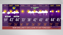
The wind ramps up once again, with gusts up to 40 mph by sunrise Sunday.
U.S. & World


Sunday stays chilly, highs mostly in the 20s and 30s, wind chills in the teens north and 20s south under variable clouds.
There’s a lot of uncertainty next week about rain and snow chances. Monday will be cold, with highs struggling to reach the melting point under a mainly sunny sky.
With cold air in place and several waves of low pressure around, the possibility for snow isn’t far off. As of now, it appears that we turn active Tuesday through Thursday, with the chance for a wintry mix Tuesday night into Wednesday morning and another storm coming in Thursday into Friday.
We will continue to monitor this active pattern in our exclusive First Alert 10-Day forecast.
