
A First Alert continues for much of New England for the upcoming midweek storm, expected to bring either side of a foot of snow to many in southern New England, with possible blizzard conditions for some.
These two days preceding the storm are classic predecessors for big snow events -- cold and fairly quiet. A northwest wind continues to ship cold air into New England on Tuesday, with sunshine and highs in the 30s but wind chill values in the 20s ahead of what will be a dying wind under a clear sky for a very cold night with low temperatures in the single digits north and teens south.
Although the wind Wednesday will be considerably lighter as high pressure -- fair weather -- crests just north of New England, high temperatures will struggle to reach 30 degrees as any limited early sun fades behind increasing and thickening clouds.
Heavy snow spreading northeast out of Pennsylvania arrives to southern New England from southwest to northeast Wednesday evening, first to Connecticut just after dinner time and to the Boston area by midnight. As snow continues to expand north through New England, heavy snowfall rates take over after midnight, with one to three inch per hour snowfall at times.
Couple this with an increasing wind on the north side of the storm circulation as it passes south of New England and not only do we see milder air changing rain to snow on the Cape and Islands, but the northeast wind gusting to 45 mph and perhaps higher at the coast will mean blizzard conditions are possible from the South Coast of Connecticut and Rhode Island Wednesday overnight to Thursday early morning, then the South Shore through southeastern Massachusetts and perhaps Cape Ann Thursday morning.
U.S. & World


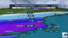
The heaviest snow rates are expected Thursday morning, tapering after midday but not before dropping either side of a foot of snow in most of southern New England, with localized amounts as high as 18 inches and lesser amounts to the north, where snow falls but less moisture is available.
Clean-up Thursday evening will be assisted by returning sun and melting on Friday and Saturday, with light rain and snow showers expected Sunday night into early Monday.
Christmas Eve Day is on the 10-day forecast. Right now it looks mild, but there is a chance of rain or snow showers at night.
