
The great weather for travel extends through Thanksgiving Day as an abundance of dry air across the country has prohibited storm development for most of this week.
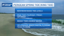
We're gearing up for some high tidal levels at the coast from Texas to Maine Thursday, Friday and Saturday at the midday high tide cycles as the New Moon is at perigee (closer to the earth than normal) and this "perigean spring tide" (unscientifically referred to as a "king tide") may deliver pockets of very minor coastal flooding to typically vulnerable spots.
Meanwhile, the otherwise quiet weather setup changes on Thanksgiving, as moisture from the Gulf of Mexico plumes northward ahead of an energetic jet stream disturbance diving southeast from the Rocky Mountains and that will result in a blossoming shield of rain from Texas to Georgia, north to the Great Lakes by later Thanksgiving Day.
Get New England news, weather forecasts and entertainment stories to your inbox. Sign up for NECN newsletters.
Eventually, that moisture will be ours to contend with in New England, but until then, cool and dry weather continues to be the theme. Of course, cool is a relative term, particularly in late November: our normal high temperature today is 49 degrees in Boston, for instance, and our forecast high is... 49 degrees! So, by this point in the season, cool is expected.
With a light wind from the northwest, Wednesday won’t feature much meaningful wind chill, and the combination of a quiet wind and partly cloudy sky overnight Wednesday night will allow for widespread lows in the 20s, ensuring chilly Thanksgiving morning road races. By middle to late morning football games, temperatures will rise through the 30s and by midday and afternoon, high temperatures top out in the middle to upper 40s. Those cheering on our local athletes at least won’t have a wind chill to contend with beyond the cool air – the wind will be light and variable most of Thanksgiving Day.
U.S. & World


Sunshine won’t be quite as abundant Thanksgiving Day as it has been leading up to the holiday, with clouds that built over northern New England each afternoon this week finally building farther south for variable clouds that, at times, will outweigh the sun, particularly in the morning and midday and especially in eastern and southeastern Massachusetts.
New clouds arrive Thursday night, this time in advance of the aforementioned storm developing to our west, and while Black Friday should dawn cloudy, it should also dawn dry. Showers arrive from west to east Friday midday and last into the evening, falling as raindrops with a mild, gusty southwest breeze for most boosting temperatures to around or over 50 degrees, but cool enough for snow showers to drop a coating to an elevation-dependent two inches in the far North Country.
Saturday looks incredible – highs in the 50s, and 40s north, with sunshine and not much wind – a great day for outdoor tasks, from hanging the holiday lights to checking the snowblower.
Of course, it doesn’t look like we’ll need that snowblower anytime in the immediate future: our exclusive First Alert 10-day forecast delivers mild rain for all of New England on Sunday from late morning onward, likely to snarl end-of-holiday travel traffic, then temperatures reach the 40s and 50s all the way through the end of next week, with a more meaningful change to colder air not expected until a few days into December.
