
The combination of early spring cool, dry air and a busy breeze is making for a classic spring feeling in New England, with high temperatures near 50 degrees Tuesday afternoon but a wind chill value closer to 40 at the warmest time of afternoon.
The result of dry air, a busy breeze and strong sun also means a boost in both pollen count and brush fire danger.
Brush fire danger
Get New England news, weather forecasts and entertainment stories to your inbox. Sign up for NECN newsletters.
Brush fires were reported in Salisbury and Devens, Massachusetts, on Monday afternoon, and our First Alert Team sees conditions as even more favorable Tuesday owing to continued drying conditions.
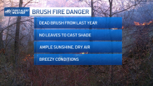
Keep in mind our ground is littered with last year’s dead vegetation – dry brush, leaves, grass, sticks and even dried reeds and grass in our area marshes. With nothing greening up yet this season and no leaves on the trees yet, this means the full effect of our strengthening spring sun shines on the dead brush, further drying it out to create what’s called “dry fuel” in the world of fire growth. The busy breeze from the northwest, gusting to 35 mph at times Tuesday into the early evening, provides ventilation to any fires that develop and also can serve to spread stray embers closer to dry fuel, igniting new fires.
U.S. & World


Of course, in New England we really don’t have any natural fire starters like the desert Southwest has with dry lightning – here, our top causes for brush fires are carelessly discarded cigarettes and stray embers from poorly managed brush burning, which means caution with these two ignition sources would nearly eliminate our brush fires.
Pollen levels today
Meanwhile, we certainly aren’t fully into spring pollen season yet, as the big offenders like birch, elm, ash, oak and pine have yet to burst onto the scene in New England, but maple pollen, juniper and poplar have begun and dry, breezy days with sunshine send the pollen count to moderate and high levels.
Relatively high pollen is expected again Wednesday but is predicted to drop Thursday as rain arrives.
Brief respite Thursday?
In fact, Thursday’s rain is the remnant of the violent storm in the nation’s midsection that spawned multiple tornadoes Monday and Tuesday from the Southern Plains to the Southeast, but as the storm hits our cooler, spring air in New England, it will transition to a cold rain for most, and a wintry mix of snow and rain in northern New England, all starting overnight Wednesday night and continuing through the entirety of the day Thursday.
Snow, flooding possible
Aside from two to four inches of snow expected in Northern Maine, accumulations in the North Country will be limited to one or two inches before a change to rain and pockets of freezing rain in deeper mountain valleys, while central and southern New England receives a fresh inch of rain – a good soaking but unlikely to cause flooding except perhaps on smaller rivers of central New England like the Suncook River in New Hampshire.
A follow-up round of energy aloft will drop over the Northeast Friday into the weekend, prompting new development of showers but this time we’re likely to find breaks between them, and any amount of sun would allow temperatures to at least rebound above 50 degrees, which is currently our forecast for at least Friday and Saturday.
Cooler air eases into New England Sunday through midweek in our exclusive 10-day forecast but also gradually dries the atmosphere until the next disturbance drives the chance of rain up again in the second half of next week.
