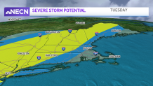
A cold front approaching from the west is triggering some showers and thunderstorms across central and northern New England Tuesday afternoon and into the evening.
Throughout the later part of the day, severe thunderstorm warnings were in place at times for parts of every New England state. As of 9 p.m., they had all expired.
Click here to see active severe weather alerts.
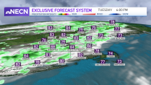
Summer heat and humidity have been with us, along with a gusty southwest wind. Highs will reach the mid 80s to around 90 for most, and the upper 70s to low 80s on south facing coastlines as well as far northern New England.
Get New England news, weather forecasts and entertainment stories to your inbox. Sign up for NECN newsletters.
Much of southern New England should remain dry during the early to mid-afternoon hours, but we can’t rule out an isolated shower or storm.
As the cold front moves through this evening, some of the storms along it may become severe, which is why we have a First Alert for this afternoon and evening newscasts.
The main threat looks to be damaging winds and hail, with the very low risk for a tornado.
Our area of focus for severe storms will be mostly across western, central and northern New England Tuesday evening into the early part of the night. Further east, a rogue severe storm may crop up, but we’re expecting the line of storms to weaken as they move closer to the coast and southeastern areas.
Overnight, showers and storms will continue to weaken as the front clears the coast late. Behind the front, we’re left with less humid air on Wednesday, but still expecting temperatures to reach the mid 80s to 90 across portions of southern New England. Highs will be mostly in the low to mid 80s north with the slight risk for a pop-up shower or storm across the higher terrain.
We’ll see a break from the heat Thursday and Friday, with the chance for more showers and storms Thursday.
Summer heat and humidity will start to make a comeback over the weekend and looks to stick around through next week as featured on our Exclusive 10-Day Forecast.