
Cold and dry air firmly in place Friday has delivered bright sun and a light wind, but temperatures will struggle to hit 40 degrees at the warmest time of the day.
Nonetheless, without the wind of Thursday, the air may actually feel the same or a bit warmer to most of us Friday afternoon, leading into a night that starts clear and sees temperatures dropping into the 20s.
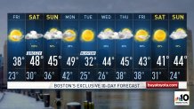
With the next disturbance arriving Saturday, the morning will be cold enough to support a mixture of rain and snow, developing from west to east during the morning.
Get New England news, weather forecasts and entertainment stories to your inbox. Sign up for NECN newsletters.
Generally, all rain will be found from the immediate Boston to Providence to Hartford metros points southeast, but the farther north and west one is, the longer snowflakes will fall before warmer air takes over from south to north, changing snow to rain as far north as Concord, New Hampshire, by mid-day, but never reaching the northern mountains before precipitation ends Saturday evening, dropping as much as five inches in higher terrain and generally two to four inches in northern New England.
Roads will be slick in northern New England on Saturday night and may turn slick overnight in central New England, with temperatures easing below the freezing mark.
Sunday isn’t going to be as warm as we’d hoped over the last couple of days because it looks like the wind just won’t be able to shift in time for truly mild air to arrive. Certainly, 40s isn’t much to complain about at the end of February, but 50s may be a bridge too far, particularly considering mostly cloudy skies will prevail as we await the next disturbance, arriving late day Sunday.
U.S. & World


Although most of us will be mild enough for rain showers Sunday late day and evening, northern New England may find a combination of rain and freezing rain with snow in northern Maine on Sunday night.
Breaks of sun on Monday should be able to bump temperatures well into the 40s and perhaps to around 50 degrees in some of southern New England before a powerful cold front arrives Monday evening with a dramatic change in air that will deliver a shot of cold Tuesday with highs generally subfreezing.
Our First Alert weather team expects new air to arrive pretty quickly behind Tuesday’s chill as New England resumes an early spring weather pattern through next weekend in our exclusive First Alert 10-day forecast.
