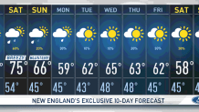
We’re finishing off the work week in the 70s! A whole week with mild temperatures, lucky us!
It's a decent afternoon, we’ll continue with a mostly cloudy sky, breaks of peeking sun and slight chances of sprinkles. It’s mainly Vermont and New Hampshire that will watch higher chances of light isolated showers popping up Friday evening. Other than that, it’s another mostly dry afternoon.
Our dew points will begin to increase Saturday as a morning warm front will push in moisture and allow for a few isolated morning showers that will likely exit early, allowing for a mostly dry afternoon for eastern New England. After 5 p.m., downpours begin to roll into western New England and advance eastward, reaching Boston by evening and toward the overnight hours.
These showers are likely to bring in some embedded thunderstorms, damaging wind gusts and heavy downpours at times. Isolated strong activity will be the highest concern. The timing should start off earlier in the day for the western part and head into Boston after 8 p.m. It will be a busy night, although rainfall amounts are not showing more than 1 inch in the east and just over an inch in the west.
Get New England news, weather forecasts and entertainment stories to your inbox. Sign up for NECN newsletters.
As for temperatures, we’ll watch these drop from the 70s Saturday to the 60s Sunday. And to start off the week, it is very likely we’ll have a significant cool down to the upper 50s in some spots. We'll have some chilly nights to start off the week until we get to midweek when temperatures rise a bit with rain chances returning by the end of the work week.