
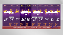
We are in a February thaw, as most of New England stayed above freezing Tuesday night, making this the warmest sunny morning since December. Though clouds are on the increase Wednesday afternoon, it remains mild with temperatures close to 50 degrees in southern New England.
It’s not too bad in northern New England either, with temperatures in the 40s for most, but there is a weather system racing out of Ontario that will clip northern New England late Wednesday and Wednesday night.
It’s low pressure riding along the boundary between the warmer air here now, and colder air that’s going to come in for the next couple of days.
Get New England news, weather forecasts and entertainment stories to your inbox. Sign up for NECN newsletters.
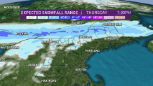
There’s quite a bit of instability along the boundary, so there will be some snow showers and snow squalls for the higher elevations of Vermont by dinner time. A stripe of accumulating snow will move from west to east through northern New Hampshire and central Maine Wednesday night. In this stripe of snow, amounts of 6 inches are possible, especially at higher terrains.
There's also a chance of a shower or flurry elsewhere overnight as a cold front sweeps through with dry air for most by Thursday morning.
Overnight lows will be in the 30s north and 40s south as the thaw continues.
Colder air works in Thursday, so temperatures aren’t going to rise too much. With a good amount of sunshine and a stiff breeze from the northwest, high temperatures will be in the 30s north and 40s south. Some upslope snow may continue in the mountains of western Massachusetts, most of Vermont and northern New Hampshire.
Wind from the northwest may gust past 30 miles an hour during the morning, before diminishing in the afternoon.
U.S. & World


High pressure moves in Thursday night with a beautiful moon light sky, and more seasonable temperatures in the teens north and 20s south by Friday morning.
With high pressure right over us on Friday, it looks like a great day with sunshine and highs in the 30s, and lighter wind.
A warm front comes in on Saturday with clouds thickening quickly and a chance of snow or rain by mid day. Any snow in southern and central New England will change to rain quickly.
The mountains may get a few inches of snow before also changing to rain at night.
That weather system should race away on Sunday, leaving a lot of moisture behind though with a chance of a few sprinkles on Sunday under mostly cloudy skies with a high temperature near 50 degrees south and cooler north.
Monday also looks fairly mild with temperatures close to 50 degrees south with sun and clouds.
A strong cold front likely moves in from southeastern Canada Monday night with a chance of snow showers or snow squalls. Much colder air comes back on Tuesday on strong winds from the north, maybe accompanied by some upslope snow once again and high temperatures Tuesday in the teens and 20s north, low 30s south.
That cold should not last long -- there’s a rebound by the middle of next week as we head into March, as seen in our First Alert 10-day forecast.
