
There’s no question Tuesday is an improvement over Monday – the wind has quieted considerably and continues to quiet during the day, the clouds are breaking up enough to allow for peeks of sun and even more than that in northern and western New England, and save for some sprinkles and flurries, rain and snow has shipped out.
While the weather may be noticeably improved, we certainly haven’t returned to normal late April weather: temperatures remain cool and sun, overall, is still at a premium.
After a cool night of clearing Tuesday night, Wednesday will start with some much needed sunshine as a bubble of fair weather strengthens over Nova Scotia. The dry and fair air emanating from the high pressure, or fair weather, center will prompt an east wind, meaning coastal communities like Portsmouth and Boston struggle to get much beyond 50 degrees, while inland communities rise closer to 60 as the pollen count increases for one and all.
Clouds will increase Wednesday afternoon well ahead of a strengthening storm center over the Ohio Valley – a storm that will eventually take a track over New England, but takes its time arriving, meaning even Thursday will feature more clouds than sun but not necessarily more raindrops than just a few showers from time to time.
Right now, the storm center is predicted to pass through New England from west to east across central New England on Friday, which would mean a southerly wind not only increases late Thursday but continues into part of Friday, ensuring this won’t be a repeat of early week cold rain for southern New England, but rather milder showers.
In northern New England, the same warmth is unlikely to be present north of the storm track, but it’s also unlikely to be as cold as the air that started the week and aided in half a foot to a foot of wet snow accumulation above 2,000 feet.
Another defining and differentiating characteristic of the Friday storm passage will be the lack of cool air behind the system – instead, milder air will arrive for the weekend with some showers possibly cropping up at times Saturday but high temperatures reaching the 60s and highs closer to 70 with a great day anticipated Sunday.
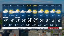
Next week starts mild, but even as temperatures cool by midweek in our exclusive First Alert 10-day forecast with another chance of rain, it’s unlikely to be as cool as the weather we’ve just experienced.
