
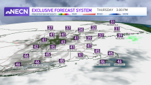
It looks like the sun won’t get to shine that much as we end the month and year on a mostly cloudy and damp note! We’ll continue to keep the threat for showers and sprinkles in the forecast Thursday afternoon, with temperatures in the 40s south and 30s north.
Another weak wave moves through overnight Thursday, bringing more showers south and snow and rain showers north. It will be exiting during the morning hours Friday.
During the afternoon Friday (New Year's Eve), the sun may break out for a bit across Connecticut, allowing temps to reach 50! The rest of southern New England will remain in the mid to upper 40s with lots of clouds. Northern areas may see a few rain or snow showers, with temperatures in the upper 30s to low 40s.
Get New England news, weather forecasts and entertainment stories to your inbox. Sign up for NECN newsletters.
Clouds will increase and thicken New Year's Eve night, with the slight risk for a sprinkle or shower, but that shouldn’t impact any outdoor plans as we ring in the New Year. Temperatures will be mostly in the upper 30s to low 40s south and 30s north.
On New Year’s Day, a stronger system arrives and brings widespread rain to the region, along with milder temperatures.
It remains mild and rainy right through Sunday morning, at which time a strong cold front will be arriving and pushing through the region during the day. Some of the leftover precipitation may change to snow as the front ushers in much colder air.
U.S. & World


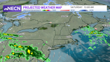
We’re also watching to see if low pressure develops along the frontal system late Sunday. If this happens, we could see a period of accumulating snow in southern New England on Sunday night. Though this is a low probability, it is something to watch! Stay tuned!
