
Even though our temperature is on the rise and the snowpack is shrinking in a lot of places, it is still cold enough for snow in the hills of western and northern New England.
Just as quickly as Monday's system raced away, another one is passing by on Tuesday afternoon. It's nowhere near as strong as Monday, but there are snow showers causing slight accumulations in the higher elevations of northwestern Connecticut, western Massachusetts and Vermont on Tuesday afternoon.
Toward the shore, we remain mostly dry Tuesday, with breaks of sunshine allowing the temperature to get well into the 40s.
Any flurries or sprinkles should evaporate Tuesday evening, with a clearing sky revealing the big bright moon. The temperature will once again cool to just about freezing, allowing for patchy black ice again Wednesday morning. It's not a very cold night by February standards, but it doesn’t take much, especially because the ground is still very cold.
Get New England news, weather forecasts and entertainment stories to your inbox. Sign up for NECN newsletters.
Yet another system is expected to track across Northern New England on Wednesday, with a chance of more snow at the Canadian border, but most of us are on the warmer side, with temperatures nearing 50 degrees in southern New England with a mix of sun and clouds. But north of a warm front in northern Vermont we may have snow squalls adding up to several inches in the mountains from Mount Mansfield northward. Also higher elevations of far northern New Hampshire in western Maine may get into some of the snow Wednesday.
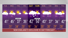
That low pressure system will move across Maine and power up on Thursday, bringing in cold and windy weather but also drier air and sunshine for our Thursday, with temperatures in the 20s north and 30s south. Wind may be gusting past 30 mph in the morning.
U.S. & World


Thursday night looks clear and cold, with low temperatures in the single numbers and teens north and teens and 20s south.
The full moon is this weekend -- it’s called the snow moon. After a dry Friday, we are going to see snow develop in northern New England on Saturday. We may have a brief wintry mix before going to rain south.
Saturday night looks rather messy. With the rain/snow line pretty close to the Canadian border, temperatures are going to jump to near 50 degrees on Saturday night for much of southern New England. Colder air will be moving in on Sunday, but not before we still maintain 50 degrees in southern New England, even as we go into the 30s in the north, with a gusty wind from the northwest.
We may have another arctic front getting close next Monday night or Tuesday that could bring another dose of wintry wind our way to start off March, perhaps like a lion. We’re also monitoring the possibility of a significant storm in the Gulf of Maine -- stay tuned to our First Alert 10-day forecast for the latest.
