
By now, many have heard about the big plume of dust spreading across the Atlantic. Is it reason for alarm? Is it another marker for climate change? How long will it last?
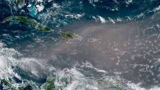
First off, it's an entirely natural process that plays out each year across the Saharan Desert. Essentially, strong winds aided and abetted by the African Easterly Jet (a topic for a whole separate blog) blow over the Saharan Desert and sweep up dust and minerals. This low-level jet stream -- dubbed the Saharan Air Layer or SAL -- has the power and longevity to propel the dust thousands of miles from its source in Africa. The dust layer can extend as high as 16,500 feet into the atmosphere. Here's the latest image with a fresh plume emerging off the coast in red (first image) and in the Gulf of Mexico (second image):
Photos: Saharan Dust Continues to Pour In
This ejection of dust into the atmosphere causes tropical systems to struggle and decay. So for a period of time, we'll be quiet in the tropics. It's not necessarily the dust itself that's to blame, but the dry air and wind shear that are detrimental to tropical systems.
Likely the most remarkable outcome of these surges of dust (there can be several in a season), is their ability to nourish the landscape. Because it originates over Central African soil that is rich in phosphorus, iron and nitrogen, it causes phytoplankton to flourish in the Atlantic and Caribbean Oceans. For that same reason, it also fertilizes the Amazon rainforest.
Most years, the Saharan dust gets little fanfare. But this is anything but a typical season. In fact, these plumes are the largest in the modern satellite era.
Photos: Saharan Dust Continues to Pour In
U.S. & World


The reason for this is likely the ongoing drought plaguing the nations of Central Africa. This drought has been prolonged by climate change, so sadly there is component of global warming playing out in the background. Typically 182 MILLION tons of dust is spread across the oceans and land masses in a season! That enough to fill over 600,000 semi trucks!
We can expect to see more of these plumes come off the African Coast in the coming weeks, causing reduced visibility and brilliant sunrises/sunsets all across the Americas.
In most seasons, our impact here in New England is often nil. The jet stream has to set up "just so" to bring in the dust, and in most years, there isn't enough to go around. This year, however, we may have an exception, since there's considerably more dust swirling in the atmosphere. Already, it has survived the trip to the Gulf of Mexico and surged as far north as the High Plains. We'll just have to wait and see if we get a turn in the coming weeks.
Photos: Saharan Dust Continues to Pour In
The season often ramps down in August as the available water vapor increases throughout the tropics and the tropical storm/hurricane season gets underway.
