
It’s around this time every year that the talk about weather shifts to the inevitable question: “What do you think winter will be like this year?”
This age-old question is one every member of our weather team at NBC Boston and necn hears, and every meteorologist is happy to take a stab at.

Of course, we take these educated guesses within the framework of statistics — and the numbers aren’t strongly in our favor/ While seasonal forecasts are, thankfully, correct more than 50 percent of the time, it’s not by much.
“Winter forecasts are a tough nut to crack,” says meteorologist Pete Bouchard, “Say mild, and everyone expects rain. Say cold, and everyone expects snow. Say what you will, but I’ve always thought seasonal forecasts are too difficult to sum up in a few sentences — never mind how they are perceived by the public. A couple of big snowstorms, and everyone thinks it was a snowy winter.”
[NATL] Extreme Weather Photos: Record Heat Threatens Europe
While our team crafts New England’s only 10-day forecast with average error of only 4 to 5 degrees a week and a half out, even those forecasters who devote their entire lives to seasonal forecasting only get marginally better results than a coin flip. Still, that does mean the forecasts are right more than they are wrong, and getting better as technology — and our understanding of the atmosphere — improves.
U.S. & World


So, with the largest weather team in New England, does this give us an advantage, or just a lot of different opinions? Fortunately, much like our 10-day forecasts, our team is mostly on the same page, and eager to merge our ideas when they differ:
Tim Kelley starts out by looking back over the weather that got us to where we are now.
“Last winter was what I call the whiplash winter, we built up the greatest snow-pack, the fastest since 1969, in the mountains of Northern New England. Then a mid-February 'heatwave' eroded 30 to 60 percent of that snow."
"Then in an amazing comeback, we actually had a typical March, which was snowier than most of the other months of winter for the higher elevations of the northeast.” Tim continues. “As summer set in, the thing that struck me most was how cold it was in Quebec, Labrador, and Greenland, where it seemed like the snow was never going to end. There was a giant iceberg of Newfoundland for most of June and July — I wondered if it completely melted at all. That cold pattern had me recalling the summers of both 2013 and 2014. In each of those summers it seemed like winter never ended in northern and eastern Canada. The following two winters were extreme, 2013-2014 in the Great Lakes, then 2014-2015 in New England.”
Viewers Share Photos of Snowfall Around Northern New England
Although past performance doesn’t equate to a predictor in the world of weather, our team does use what are called “analogs” in our forecasts, both day-to-day and looking at seasons ahead. Analog patterns are similar patterns that happened in the past: when did the jet stream look like this? When did the temperature pattern across the country, the hemisphere, the globe look like this? What type of weather was observed in those similar setups in the past, and does it seem possible that could happen again? If you can find an analog, you have a metaphorical thread you can pull to see what might unravel.
Tim chimes in again, pulling that thread: “At the Blue Hill Observatory, 2017 was the warmest October on record, beating out 1947 and 1963, among other years. Looking back at the winter of 1947-1948, it was a record for snowfall up to that time, 63.2 inches at Central Park in New York City. The winter of 1963-1964 also evolved into an extreme winter, with heavy snows from Texas to the East Coast, including some all-time record snowfall, including a blizzard of note here in the Northeast in January, and the 'Crown of Winter’ storm in March. And this new record we tied this week in Boston for longest streak of 40 degree or warmer days at 201 consecutive days matches up — this warm streak tied 1968 as the longest such streak. The winter of 1968-1969 went on to be the snowiest winter on record (still standing) in the mountains of New England.”
Not only can we gain insight from past years of weather, but also by looking at how the pattern is setting up now, in autumn. There was a time when the winter jet stream pattern would lock in for the season in November, giving a really good idea of how the season’s weather would shake out. That’s tougher now.
One reality I’ve noticed over the past several winters is the abundance of warmth in the atmosphere — with very noteworthy exceptions. The past several winters have shown above normal temperatures for so much of the Northern Hemisphere, but always with a couple of persistent, almost semi-permanent pools of colder-than-normal air and associated snow. That same pattern has already set up over the last few months, seen in the map here — a display of how warmer and colder-than-normal atmospheric temperature through the lowest 20,000 feet, averaged over the last three months.
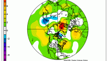
Notice all of the warm colors — lots of warmer-than-normal places and very small colder-than-normal areas. This makes it pretty tough to get a colder than normal winter, because even the more intense bursts of cold are relatively small and remain transient.
Michael Page agrees: “Given the atmospheric setup, it seems like a very good bet winter will end up being warmer-than-average on the whole, even with typical colder periods mixed in.”
Pete adds, “While the cold will be short-lived, the warm-ups will dominate longer thanks to frequent flexes from what we call stratospheric warming (brought about by diminished ice in the Arctic).” That stratospheric warming — warming in very high altitudes — has been shown to send bundles of extremely cold air southward from the North Pole, and was a driving force behind the now-infamous “Polar Vortex.”
Jackie Layer came to Boston from the Midwest, and remembers that intense cold well: “My first winter in the Midwest back in 2013-2014, which finished in the top five snowiest and coldest on record for northern Indiana and southwest Michigan, even the Great Lakes reached a new record high in terms of percentage of the lakes that froze over."
"I will never forget just how cold -40 degree wind chills felt when I had to start my car multiple times overnight to ensure that: 1) my car wasn’t completely covered by blowing and drifting snow, 2) frozen shut (the trunk was completely frozen shut by 10 p.m.), and 3) it would be drivable when I had to go into work the next morning at 4 a.m."
Keep in mind: if our team is right and we see warmer-than-normal temperatures with incursions of intense cold from time to time, those warm/cold clashes create storms, meaning incursions of cold will increase the likelihood for periods of moisture-laden, active storms.
“At the same time,” adds Tim, “thanks to such a warm first part of autumn, the sea surface temperatures off the eastern United States are well above climatological average. Also, the Great Lakes have some of the warmest water we've ever seen for this time of year. When extra cold air moves over extra cold water we can expect extra strong storms.”
Chris Gloninger says Northern Hemisphere warmth has already had an impact, even this early in the snow season — overseas — but has shown signs of turning around in the last few weeks. “During my time in college at Plymouth State (University), I studied patterns to try and accurately predict seasonal snowfall. One of those methods? Looking at snow cover thousands of miles away in Eurasia! With data reaching back to 1970, you can find a recurring pattern —when there is significant snowfall across Eurasia early in the season, expect a snowy winter in New England."
"Well, if you were looking to make this forecast in early October, there would have been a lot of disappointed snow lovers. In the recent weeks, we saw a MAJOR turnaround. There has been a significant amount of snow in that part of the world. So, if you look at that statistic, expect average to above average snowfall this winter!”
Chris isn’t alone in looking outside the country for clues — Tim focuses on Canada.
“And the most recent development is early this November, the northern hemispheric snow cover going one standard deviation above 'normal' in the first six days of the month," Tim says. "Across Canada and the northwestern United States, the early November snow cover is close to two standard deviation's above climatological average. That means that any discharge from the north pole is going to be crossing land that's covered with snow and ice, therefore delivering shots of colder weather than you might normally see this time of year."
In our weather specials over the past year, Pete covered New England’s historic drought extensively, but he agrees with Chris that we should see above normal precipitation this winter, and probably above normal snow in a fluctuating pattern.
“With global warming pulling the strings, no three months are the same and no theme seems to resonate for the entire season," Pete says. "We’ll see our fair share of snow — likely running above normal thanks to jacked up storms — but we’ll have our outrageous thaws and at least one or two numbing blasts of arctic air. While the cold will be short-lived, the warm-ups will dominate longer thanks to frequent flexes from what we call stratospheric warming (brought about by diminished ice in the Arctic). With La Niña at play, the West (U.S. and Canada) is favored for more frequent spells of cold and we’re favored for warmth. But here’s the catch. Weak La Niñas favor more acute regions of cold/warm, while strong La Niñas seem to mellow the extremes and flood the Lower 48 with mild air.”
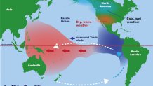
La Niña? La Niña is the opposite of El Niño, but both represent changes in Pacific ocean temperature and barometric pressure. In an El Niño weather pattern, warm ocean water expands across the Pacific Ocean, near the equator, while La Niña sees colder water temperatures. With the Pacific Ocean so expansive, changes in water temperature surely can mean changes in atmospheric steering wind, too, and that can alter weather patterns, especially in North America.
"With the National Weather Service Climate Prediction Center issuing an announcement in early October that a La Niña Oscillation is likely panning out in the equatorial Pacific,” adds Jackie, “that pattern usually slides the Jetstream across the Midwest, slightly southward tapping into the Tennessee Valley, and then northward into New England, as opposed to an El Niño pattern that would favor a polar jet stream to slide it’s way southward into northern New England and oscillate southward at times.”
Noting the abundant warmth could make above-normal snowfall a challenge, Michael adds, “I have a hard time seeing anything to suggest we’re in for a super snowy year; seems like near normal (with a little wiggle room on either side) is reasonable.”

Personally, I tend to agree for Southern New England, in particular, as the warm ocean water and the warm atmosphere, in general, argue for multiple events of snow changing to mix or rain this winter, especially if storm tracks resembling our rare, damaging wind “sou’easter” continue — even a shift just off the coastline as nor’easters could make it tough to hold big cold in Southern New England when storms come calling.
Of course, we all realize that when it comes to seasonal snowfall, one or two extreme storms can make literally all the difference.
“Add up all of these factors, and it leads me to believe that we are going to have an extreme winter. Very powerful storms, with more than one blizzard. Also, strong, cold high-pressure systems that pass to our north generate lower layer heavy cold air in the valleys of New England, so I would also expect a serious ice storm or two,” adds Tim.
Jackie adds support. "With the fluctuating temperatures, I wouldn’t be surprised with a couple of ice storms.”
In set-ups like these, often we see a zone of heavy snow well north of the storm track, so we’ll watch Southern Canada and Northern New England to fall into a heavier snow belt, north of the mixed precipitation zone.
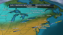
So, putting it all together, our NBC Boston and necn weather team calls for warmer-than-average temperatures overall this winter, interrupted by a few surges of intense cold.
Multiple mixed precipitation events — some of the storms intense to extreme — will make for more precipitation than normal, and, particularly as the occasional surges of intense cold depart, the ingredients will be in place for a blizzard or two as the cold/warm clash rages, in a tendency back to warm.
This adds up to a solid ski and snowmobile season in the North Country, and a messy pattern favorable for slushy travel days in Central New England and big fluctuations in temperature, breeding extra potholes in Southern New England, even if the depth of snow on the ground is more limited than in some years for those southern areas.
