
The wind continues to diminish gradually tonight and we will be left with a light breeze by Saturday afternoon and Sunday.
Tonight will be frosty for inland areas as temperatures fall to the 30s. Larger cities and areas on the coast should stay in the low 40s, so just a tad too mild for frost.
After a cold start to the morning, we rebound to highs in the 50s and low 60s under full sunshine on Saturday. The Head of the Charles Regatta forecast will be great with seasonable temperatures both days and not too much wind.
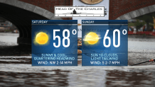
Sunday will bring increasing clouds from the south and highs around 60 degrees.
Tropical Storm Nestor has formed across the Gulf of Mexico and will make landfall Saturday on the Florida panhandle. It will continue to track northeast and head off the Carolina coast by Sunday night.
This storm seems to stay away from us in the northeast, but then the remnants meander northward and help to enhance some of the rain and wind from an approaching cold front on Tuesday.
U.S. & World


Scattered rain and gusty wind will move in Tuesday through Wednesday with some snow in higher elevations late Wednesday.
The rest of next week will be dry and in the low 60s. Next weekend we may be dealing with a coastal storm but stay tuned!
