
Official temperature measurements are taken in the shade – so when you’re out in the sun it often times feels warmer than what the thermometer reads. High dew points also can make it feel warmer than the actual temperature.
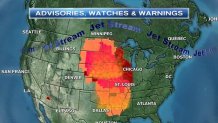
When dew points climb into the 60s it’s uncomfortable, when they’re in the 70s it feels like Florida. Over the next couple of days, dew points in the Midwest will reach 80°. The heat indices (the summer equivalent to wind chills) will climb to 120° in some areas! Excessive heat warnings, watches and advisories are highlighted on map below:
The jet stream is pushed north into Canada and then drops into New England. That means two things for us: 1) we are going to get hot (not as hot at the Midwest – closer to 90°) and 2) our weather turns active with a chance for severe thunderstorms on Friday.
First, let’s talk about the heat. Temperatures will reach the low 90s between Thursday and Monday. That would be the first heatwave of 2016 in Boston. We just missed a heat wave over the weekend, because temperatures were knocked down into the 70s on Sunday. Inland locations did, however, experience a heat wave. The last official heat wave in Boston was in 2015 between September 7th and 9th.
Meteorologist Matt Noyes' Pics of the Day
Severe weather could return on Friday. As the jet stream cuts across New England, it puts us in a favorable position for strong to severe thunderstorms. At this point, it’s too early to pinpoint specific locations, but damaging winds and large hail are possible. Stay tuned to necn as we fine tune this forecast.
