
The combination of tropical moisture following north from the Gulf of Mexico, combined with a series of weather fronts moving south from Canada, puts New England squarely in the battle zone for off and on heavy rain through the weekend.
It's not a case where it is raining everywhere all the time, but when it does rain it really pours. We call these downpours "gully washers."
--> WHEN WILL THE RAIN HIT? INTERACTIVE WEATHER RADAR <--
Rainfall amounts of more than one inch were reported in parts of central and western New England by mid-morning Wednesday. Downpours are moving from west to east at a steady clip, but it is a case where you get more than one downpour.
It's good news to help alleviate the drought a bit.
But it is not widespread rain. Some areas are not getting any rain at all - for example, toward the Canadian border is mostly dry today.
Attempting to place and time the individual heaviest rain clouds is our challenge of the day.
Local


--> LATEST SEVERE WEATHER ALERTS <--
Here are a couple of estimates for Wednesday afternoon.
Around 1 p.m. we see the steadiest heavy rain moving across eastern Massachusetts, southeastern New Hampshire and Rhode Island.
At 3:30 p.m. we will have sunny breaks in parts of New England, which will help initiate a few thunderstorms as shown in the graphic by the darker red spots.
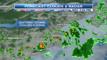
As the sun goes down the showers and storms should diminish to scattered sprinkles, allowing the Red Sox to get a game in this evening.
We are now on the warm side of the front, with very humid air through the next few days.
High humidity, combined with the proximity of a stalled front, will generate more showers and thunderstorms scattered around New England on Thursday.
The map for 3:30 p.m. Thursday indicates temperatures in the mid 90s, with scattered thunderstorms which again will produce localized torrential downpours.
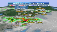
In addition to rainfall possibilities, we have a heat advisory for eastern Massachusetts Thursday, with temperatures in the 90s and dewpoints in the 70s. Our heat index will approach 100 degrees. Friday and Saturday look similar, with hot weather and scattered heavy thunderstorms.
The weather map may change a bit for Sunday and Monday as the wind comes more from the northeast, bringing the temperature down. But we are still very humid, with off and on downpours into early next week.
It's a bit early to cancel weekend plans, as parts of New England may end up with many hours when the weather is pretty nice. We will keep you posted with more updates as soon as they become available.
