
It wasn't the temperature, it was the wind that got you Friday, wasn't it? Very understandable, given the frequent gusts to near 40 at times.
Thank the colder air in the upper atmosphere and the higher late-February sun angle. The two just don't get along. Nor do they in March - or April and May for that matter. Simply put, a higher sun angle means the mixing in the lowest levels of the atmosphere is more intense. So it stands to reason that this can be the windiest time of year.
Sun angles aside, we ARE warming this weekend, albeit slowly. A warm front sliding through tomorrow afternoon will be too little too late to boost Saturday's temperatures, but it will give us a milder night Saturday night and rocket us into the 50 degree range by Sunday.
But it's not all cut and dry. A cool front will sneak down Sunday afternoon, and given its approach from Maine, I'm wary it may drop into Coastal Massachusetts in the afternoon, plunging out temperatures into the upper 30s to low 40s late day. It's the notorious Back Door Cold Front, and based on past experience, all options are on the table. Rarely does it stall near Portland like the models are suggesting. And given the transition to "spring", I'm going with a cooler afternoon.
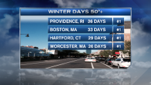
The point is moot, however. The warmer air will win out for Monday as we soar to the mid and upper 50s - for the 34th time this meteorological winter (Dec-Feb) in Boston and 27th time in Worcester.
Cooler air returns Tuesday, but not enough to ensure our next storm system Wednesday will be cold enough for snow. Instead, I think we'll start off March like we finished February - with 50s.
Local


Clearly a spring mode now. Go ahead and insert a fork in winter.
