
Areas that saw their first accumulating snowfall, will see drier conditions for Friday.
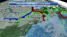
However, snow continues into northern Maine and pockets of snow showers still remain over higher elevations in Vermont and New Hampshire. The system that brought drenching rainfall for southeastern New England, the first accumulating snowfall for western Massachusetts and Connecticut, will slowly shift northeast and eventually off the coastline for the rest of our Friday. We certainly are making a dent in the severe to extreme drought that has been looming over the area.
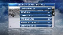
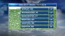
Here’s a look at storm-rainfall and snowfall totals below through Friday morning:
Once this low pressure system moves off the coast, New England will then be on the backside of this system, ushering in blustery northwesterly winds, especially along the coastal areas.
So, let’s break down your weekend forecast so you can prepare ahead of time for any of your outdoor weekend plans.
Northern New England
Local


Friday: Rain sticks around for most of the day, especially in Maine with snow mainly in higher elevations. Blustery with temperatures will remain into the upper 30s to low 40s for most.
Saturday: Another round of showers move in by the afternoon and extending into the evening. These rain showers could change over to snow in higher elevations. Showers spread from west to east. Highs will stretch into the mid to upper 40s.
Sunday: Drier conditions move in for the second half of the weekend. More clouds than sunshine. Highs near 50.
Southern New England
Friday: Peaks of sunshine for CT, and western Massachusetts, pockets of showers move in by late afternoon and into the evening for eastern Massachusetts. Blustery through the afternoon with temperatures into the upper 40s
Saturday: Mostly to partly cloudy, breezy and mild with highs into the low to mid 50s.
Sunday: A spotty afternoon shower is possible. Otherwise, mostly cloudy with highs into the mid to upper 50s.
On Halloween, high pressure dominates, ushering in the southwesterly flow, calmer conditions, mostly sunny skies with highs into the low to mid 50s south and upper 40s north.
As always, you can download the necn weather app so you are always up to date with the very latest forecast on the go.
