
-
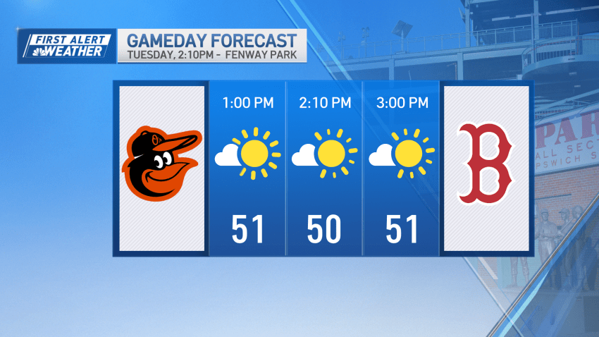
Here are Boston Red Sox home opener weather stats
We’re feeling and looking like real spring around here but another true sign: the Boston Red Sox home opener on Tuesday! Our average high on opening day is 57 at Fenway Park in Boston. Of course, the date varies each year. First opening day at the ballpark was in 1901 and that’s how far back our records go for weather…
-
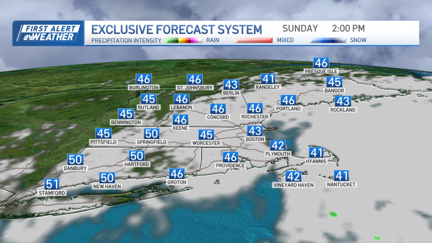
Clearer skies on Monday will allow better view of solar eclipse
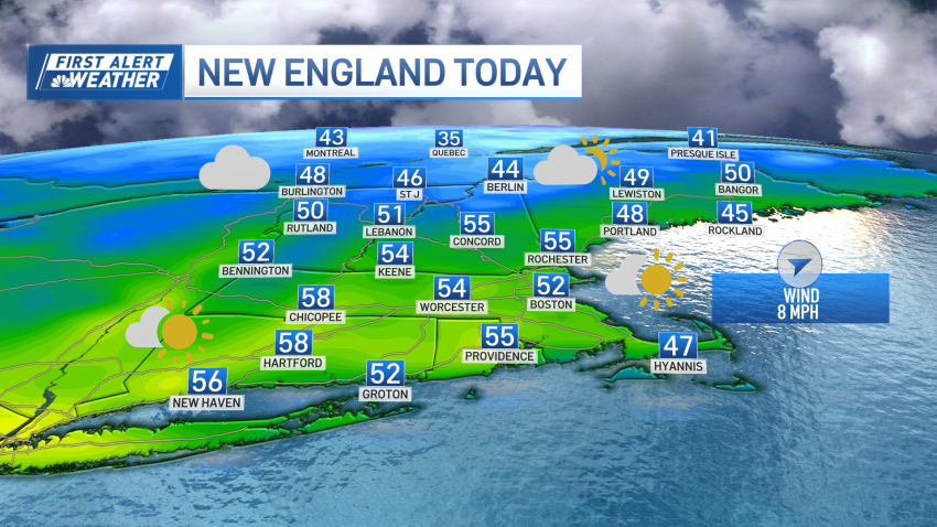
Low pressure offshore will finally move far enough away from the region taking its clouds and precipitation with it as we head through the course of the afternoon and evening on Sunday. Other than some stubborn clouds along the coast with a few lingering showers and sprinkles across southeastern Massachusetts, the rest of the region will be on the...
-
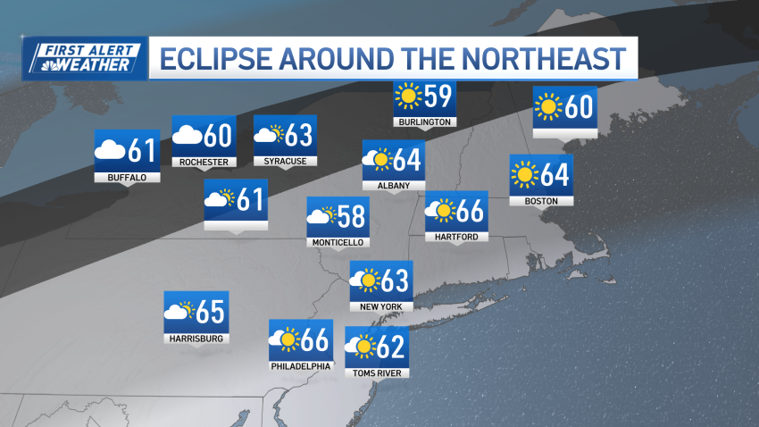
Chilly and breezy Sunday morning in New England before clearer skies on Monday
The clearing overnight Sunday into Monday will make way for a great eclipse forecast.
-
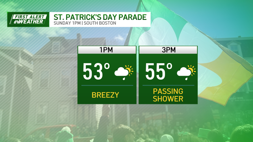
Mostly clear St. Patrick's Day before a cooler week ahead
Other than a gusty west wind, the St. Paddy’s Day Parade in Southie should go off as planned, but watch out for a stray shower/sprinkle through the mid-afternoon.
-
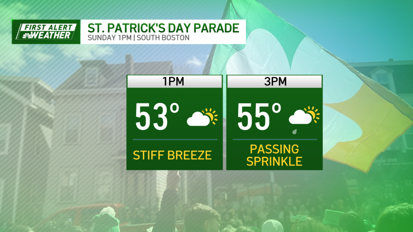
Mostly clear and breezy St. Patrick's Day
A sprinkle or two possible during the parade, but it will not be washed out by any means.
-
Sunny Saturday before fog and drizzle overnight
By the afternoon, the front will clear the coast leaving behind some clouds which may produce a quick sprinkle or shower, but those will be few and far between.
-
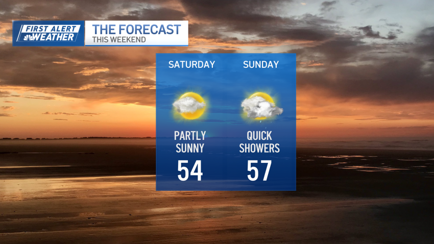
Kicking off the weekend with a sunny Saturday
The parade in Soutie should be mostly dry, with just a slight chance at a passing shower.
-
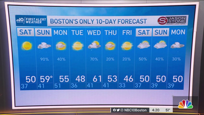
Forecast: Light rain Friday, showers return Sunday
Friday: Light morning rain to midday sprinkles. Highs in the mid-to-low 50s.
Saturday: Sun & clouds. Highs around 52°.Follow NBC10 Boston on…
Instagram: instagram.com/nbc10boston
TikTok: tiktok.com/@nbc10boston
Facebook: facebook.com/NBC10Boston
X: twitter.com/NBC10Boston -
Freezing Temperatures Saturday Evening Could Cause Slick Road Conditions
Wet roads today (Saturday) could mean slick roads tonight. As temperatures drop across the region to 32 and below, wet roads have the chance of freezing. More snow will come its way Sunday morning, accumulating mostly on the coast of Massachusetts.
-
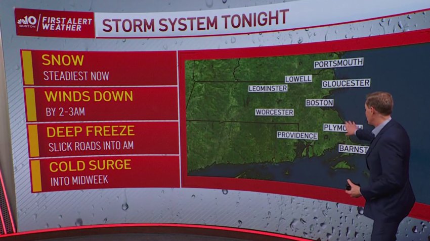
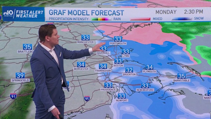
FIRST ALERT: Steady Snow Until 3AM, Slick Roads Into Monday Morning
Snow continues with a variable pace through 2-3am, then shrinks to the South Shore and finally out to the Cape by morning. Snow/rain showers will mix on the Cape until mid-morning Monday, with little to any accumulation there. Roads are slippery already, and will remain so as the temps fall to the low and mid-20s.
-
Forecast: Northeast Travel Could Be Icy Friday Night
Friday night: clearing skies, lows in the upper 30s, windy.
Saturday: Sunny, mild, breezy. Highs around 50.
Sunday: Scattered rain & breezy. Mostly cloudy, Highs in the upper 50s. -
Forecast: It's Freezing in Boston
Sunday Evening: a slight chance for brief/spotty snow showers.
Sunday night: lows in the mid 20s. Mostly clear. Gusts around 30 mph. Monday: Sunny, highs in low 40s, SW wind gusting over 20 mph. -

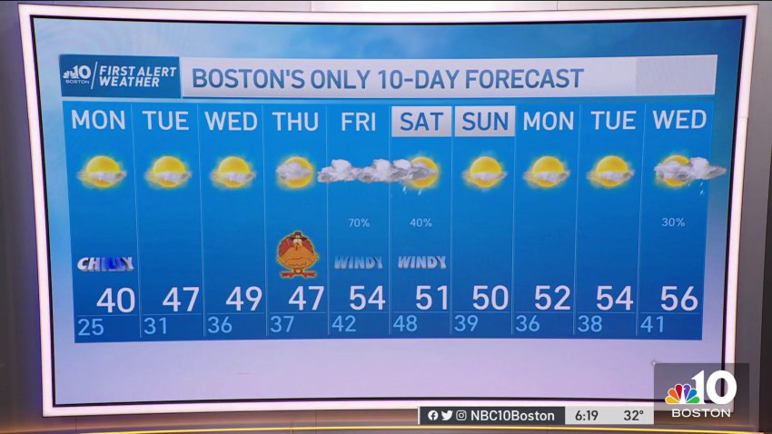
Forecast: Cool and Quiet Now, Festive Flakes Ahead
Overnight: Mostly Clear. Temperatures cool into the mid-to-upper 20s.
Sunday: Highs in the upper 30s to 40°. Chance for a quick flurry west. Windy with occasional gusts approaching 40mph.
Monday: Morning starts chilly in the 20s. Feels like temperatures between 10 and 15°. Highs near 40°. -
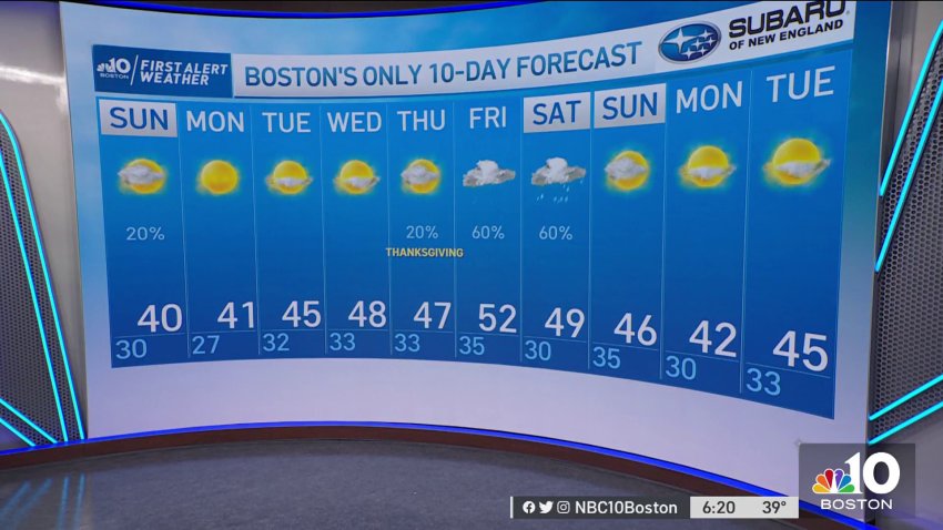
Cool and Quiet Now, Looking Ahead to Thanksgiving Forecast
Overnight: Mostly Clear. Temperatures cool into the mid-to-upper 20s.
Sunday: Highs in the upper 30s to 40°. Chance for a quick flurry west. Windy with occasional gusts approaching 40mph.
Monday: Morning starts chilly in the 20s. Feels like temperatures between 10 and 15°. Highs near 40°. -
Forecast: Coldest Air of Season on Its Way
Overnight Friday Night: Partly cloudy, South Coast mixed showers. Lows in the 20s.
Saturday: Fair, Cape/Islands chance shower. Highs in the 40s.
Sunday: Early AM Cape mixed showers, otherwise windy and chilly, fair sky. Highs around 40, wind chill 30. -
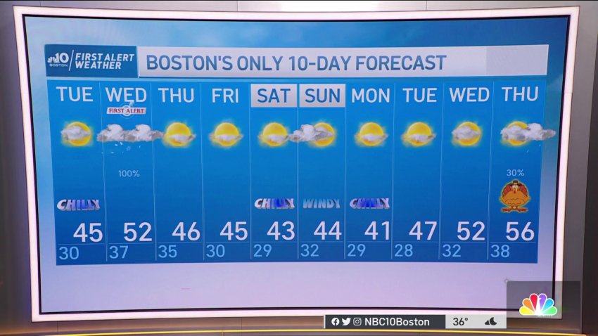
Do We Have Any Snow in the Forecast?
Overnight: Lows in the low 30s to upper 20s west. Increasing mid-level clouds.
Friday: Highs in low-40s. Sunny AM, passing clouds PM, ocean-effect showers in south shore. Snow squalls possible inland (late evening). Saturday: Highs in low 40s, mostly sunny, southwest wind. -
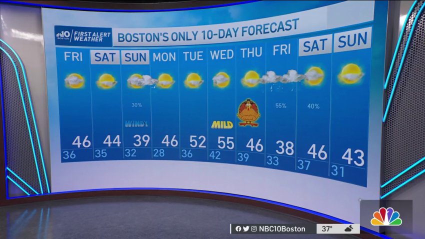
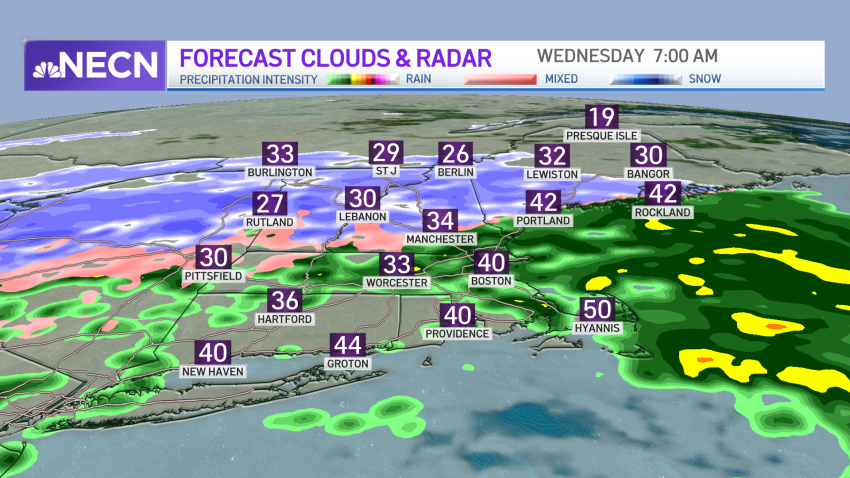
Forecast: When Do Rain, Wintry Mix and Snow Arrive in New England?
Overnight Monday night: Diminishing wind. partly cloudy and cold. Lows in the 20s.
Tuesday: Increasing clouds. Night rain arrives, mixed with snow well inland. Highs in the 40s.
Wednesday: Areas of rain and wintry mix well inland. Highs in the 40s, 50s Cape Cod -
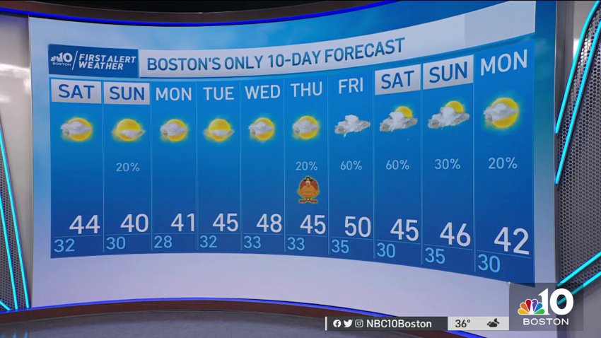
Timing and Snow Totals: Breaking Down the Impacts of the Winter Storm Moving In
We’ve made a sharp return to reality after record warmth to kick off November and several warm days as of late. Now, the chill has settled back in and it’s here to stay, which means that you knew that it was only a matter of time before we’d be talking about snow! In fact, the morning sun tomorrow will fade...
-

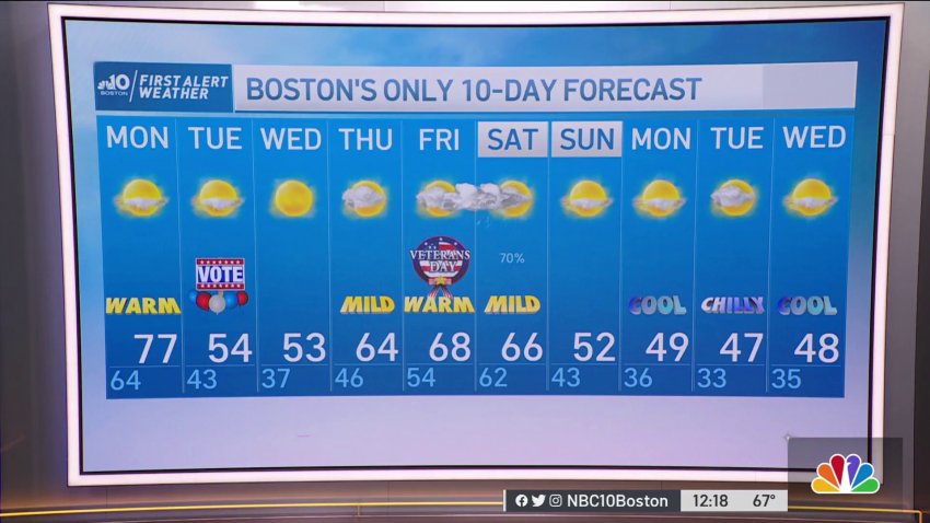
Forecast: Cold Air Set to Move in for Election Day
Overnight Tonight: Clear, breezy and chilly. Lows in the 30s.
Tuesday: Much cooler with sun and a crisp breeze. Highs in the 50s. Wednesday: Mostly sunny. Less wind. Highs in the low 50s. -
Forecast: Another Unusually Warm Day Monday
Sunday night: Few showers northwest. Mild. Lows in the mid 60s.
Monday: Early showers, partly cloudy. Breezy. Highs in the mid 70s.
Trending
