
-

NH braces for an April snowstorm as coastal communities prepare for wind
April showers bring… a nor’easter to New England. Just when you think it’s safe to put away the winter gear, from heavy jackets, to shovels and ice melt, the season strikes back. When it comes to weather in New England – you have to expect the unexpected. “We’ve already sold some rock salt today, we’ve sold some wood...
-
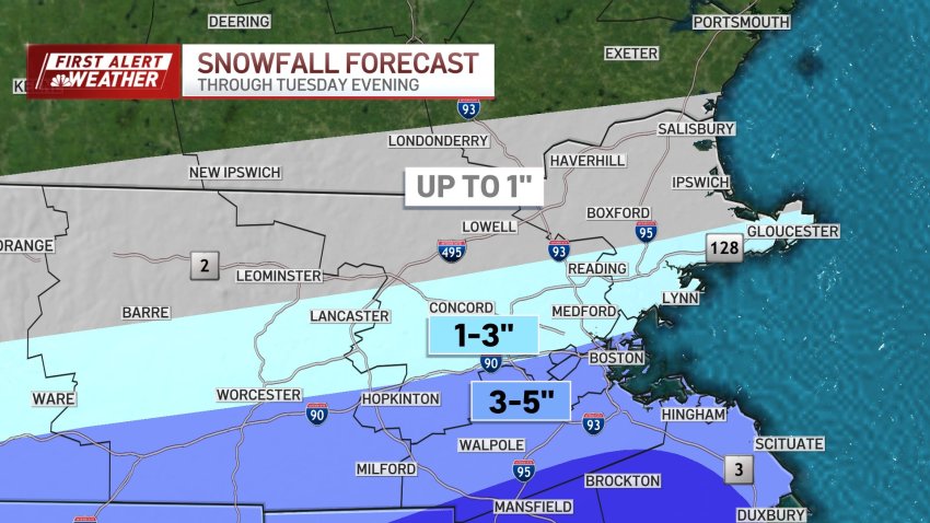
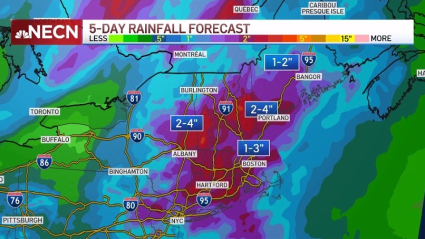
SNOW MAPS: With storm shifting, how much snow will we get from Tuesday's nor'easter?
As a nor’easter approaches Tuesday New England is preparing for a storm that could drop a foot of snow in some areas. Schools have already announced closures, with more expected as the storm moves closer, but as of Monday afternoon we’re watching some new patterns emerging that will change where we expect to see the most snowfall. The low...
-
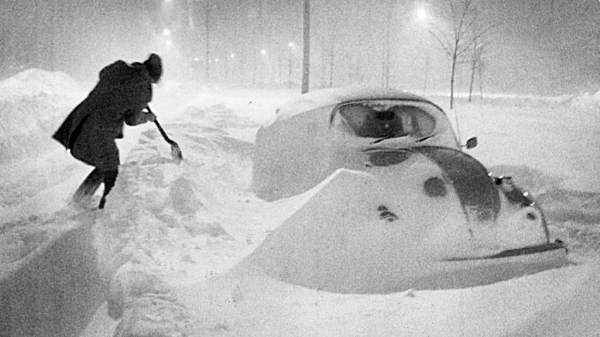
Blizzard of '78: 46 years later, a look back at the storm that crippled New England
Forty-six years ago, the Blizzard of ’78 was exiting New England, concluding 36 hours of aggressive snow, wind and rounds of coastal flooding that left a lasting impact on the region. Beyond its status as a significant snowstorm, the event fundamentally altered the way an entire generation interpreted major snow forecasts. The storm hit New England on Feb. 6 and…
-
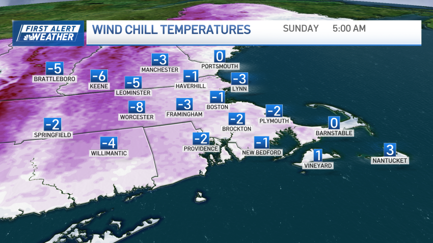
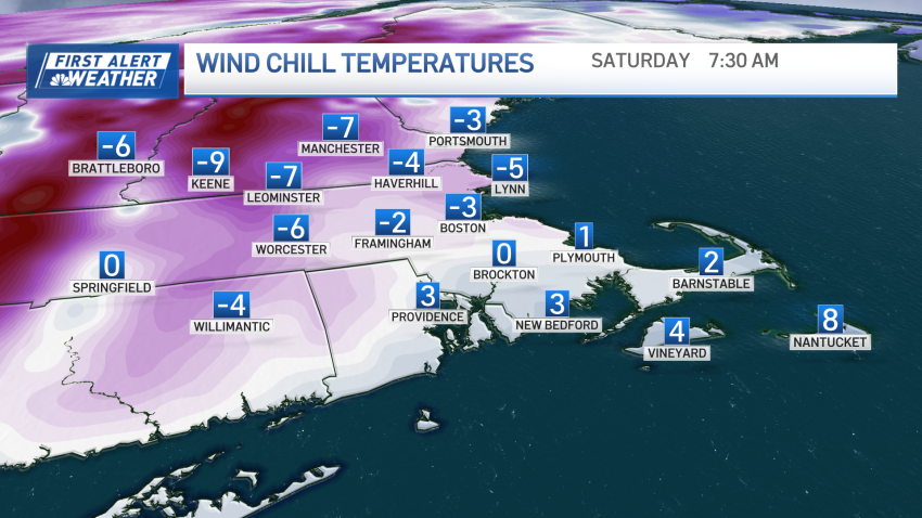
Wind chill in the single digits in New England during the weekend
Your Saturday morning begins with windchills in the single digits above and below freezing. A frigid weekend is ahead. For Saturday, temperatures will stay 10-20 degrees below normal. With wind gusts near and above 20 mph. Cloud cover is expected due to a shortwave, limiting sunshine. Highs will be in the teens to low 20s, and it will be gusty....
-
Below-freezing stretch continues through the weekend
New England is in the thick of the lengthiest cold stretch since 2021. Temperatures plunged below freezing in Boston Tuesday evening and are expected to stay below freezing until next week. The Boston area has been below 32 degrees for over 48 hours. When all is said and done, we will likely see five days and nights that we don’t…
-
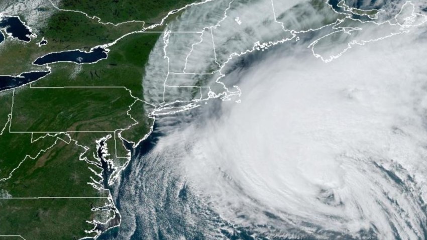
Hurricane Lee: Potential impacts as the storm moves into New England
We’ve been keeping very close tabs on the track of Hurricane Lee for the last several days now. We’ve been monitoring whether or not Lee was going to make more of a shift to the west and bring it closer to the New England coast. To this point, the shift farther west has not happened. The odds are much...
-

First Alert Forecast: Wind increasing as Hurricane Lee nears
Friday: Cloudy with comfortable air, breezy late. Highs 65-70. Overnight Friday night: Tropical Storm Warning at the coast. Rain arrives to the coast, wind increases as fringe of Hurricane Lee arrives. Lows around 60. Saturday: Coastal wind & rain worst in the morning and midday, then improving. Midday coastal flooding for some. Inland windswept showers. Scattered power outages. Highs 65-70....
-

Thousands still without power after storms in Mass., including 50% of Andover
Thousands are still without power in Massachusetts and parts of New England after storms hit the region on Friday. As of 2:30 p.m. on Sunday there are over 14,000 people without power in the state, according to MEMA. Almost 50% of the town of Andover, Massachusetts are still without power on Sunday morning. The city has opened a cooling center…
-

Thousands still without power in Massachusetts after storms
Hours after powerful storms hit multiple states in New England, neighbors are still trying to pick up the pieces. As of 11:30 p.m. on Saturday, over 23,000 people were still without power, according to the Massachusetts Emergency Management Agency. More than half of those outages were in the towns of Andover and North Andover alone. Visibility in Andover was low…
-

Storms knock out power, leave trees in roadways and on train tracks
Severe storms left tens of thousands without power Friday in Massachusetts as downed trees caused transportation problems. As of 8 p.m., more than 63,000 Bay State customers had no power, according to the Massachusetts Emergency Management Agency. In Andover, two people were hospitalized after a tree crashed into their home. Aerial footage in Acton showed several vehicles crushed by trees…
-
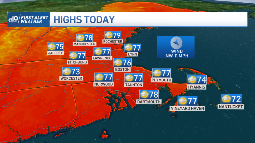
Refreshing air and drier days ahead in New England
Wow! What a difference the drop in humidity has made. After the passage of last night’s cold front, temperatures have dropped to the 70s and our dew points took a dip to the lower and mid-50s, which makes it so refreshing. Windows may be opened again, sunglasses will be needed and if hiking high in the mountains, take the...
-
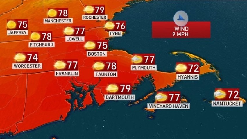
Dry, sunny Sunday after severe weather
After a rough and tumble Saturday, Sunday is going to be a great day to catch our breath. Some spots picked up more than three inches of rain on Saturday, adding to an already very wet July. Cooler and drier air has now spread across all of New England. We will all enjoy a phenomenal second half of the weekend!…
-
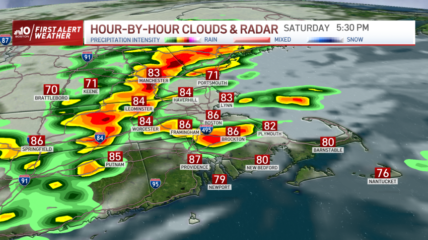
FIRST ALERT: Tornado warnings expire in southeastern MA, northern CT
Another warm and muggy start to the day has led to strong to severe storms throughout the rest of Saturday. Our weekend is absolutely split, there will be a significant chance in the dry airmass that will take over our Sunday opposed to the hot, humid and stormy Saturday we’re dealing with now. Click here to see active weather...
-
FIRST ALERT: Tranquil weather turns turbulent Saturday morning, severe weather likely by night
Two consecutive days at 90° means our heatwave potential is still intact. We haven’t seen a 3 day streak since last August, but Saturday could meet the mark as heat surges in. The heat and humidity will couple to bring another threat of severe activity. Isolated showers will move across the South Coast of New England through spots of Rhode…
-
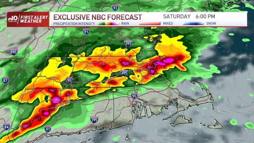
FIRST ALERT: After a hot Friday, severe storms and flooding possible Saturday
It’s been a hazy, hot, and humid end to the week and that heat/humidity combination will carry over to the first half of the weekend. See a full list of severe weather alerts here. Saturday will start warm and humid with a partly cloudy sky. Temperatures will climb into the 80s to around 90 by early Saturday afternoon. Scattered...
-

Heat emergency declared in Boston Thursday and Friday
The city of Boston is declaring a heat emergency for Thursday and Friday, where temperatures are expected to rise into the 90s and heat indexes are expected in the mid-90s up to 100 degrees. Cooling centers will open to all residents at locations across the city. There will be 15 Boston Centers for Youth & Families (BCYF) community centers open…
-
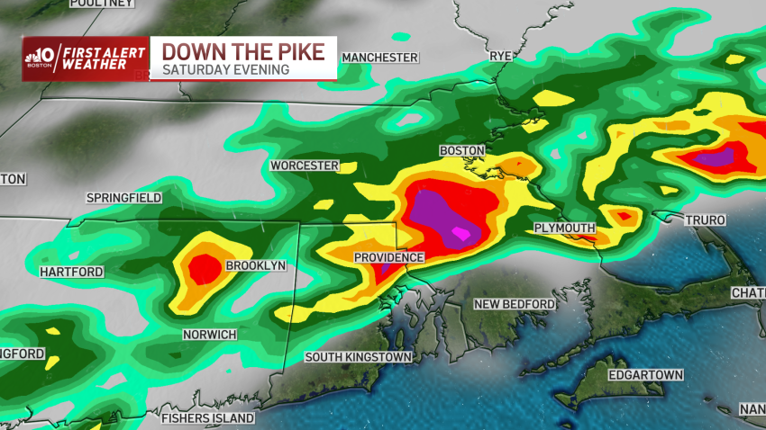
Weather forecast: Highs in the 80s with isolated storms
Saturday night: Partly cloudy, mild and muggy. Lows in the upper 60s to low 70s. Saturday: Partly cloudy with a few isolated showers/storms. Highs in the low 80s. Sunday: First Alert: Widespread showers and thunderstorms, highs in the upper 70s to low 80s. Monday: Hot and humid with a few stray storms possible. Highs around 90.
-
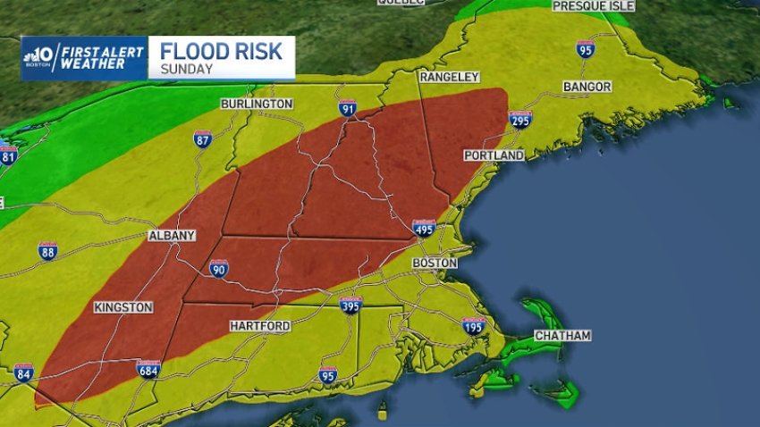
FIRST ALERT: More flash flood warnings in Vt.
It’s been a busy week with several rounds of heavy rainfall across parts of New England and we’re not quite done with the flooding threat. There are flash flood warnings in parts of Vermont, still dealing with the aftermath of severe flooding earlier this week. They will be in place until 1 a.m. in Addison County, Washington County, Rutland...
-
FIRST ALERT: Thunderstorms, heavy rain move through New England
There are severe weather alerts in place in much of New England Thursday evening. A tornado warning was effect in parts of Vermont, including Essex County, Addison County and Rutland County. It expired at 6:45 p.m. Flash flood warnings were also in effect in much of the state, which was already inundated by floodwaters. Those warnings have since expired. Early…
-
Drab and dreary weather continues, with chances for thunderstorms Tuesday
The work week has picked up where the weekend left off, with drab and dreary skies and rain. And to make matters worse, Tuesday will bring about isolated pockets of severe thunderstorms and downpours. A stalled area of low pressure south of Halifax will continue to keep cloudy skies and cooler air overhead for the week. In spells, sun does…
Trending
