
-
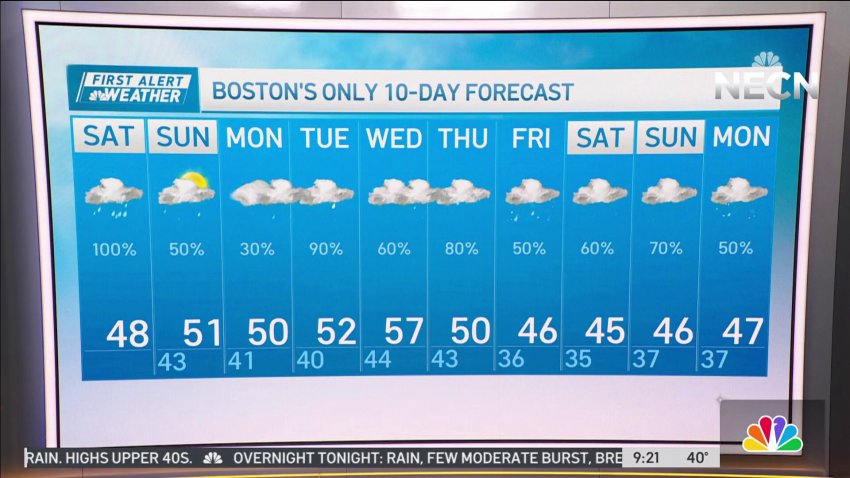
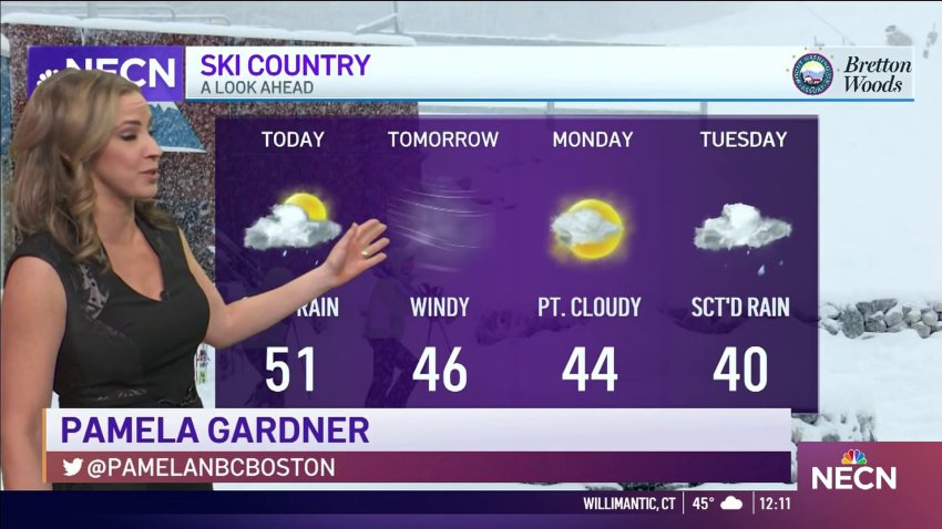
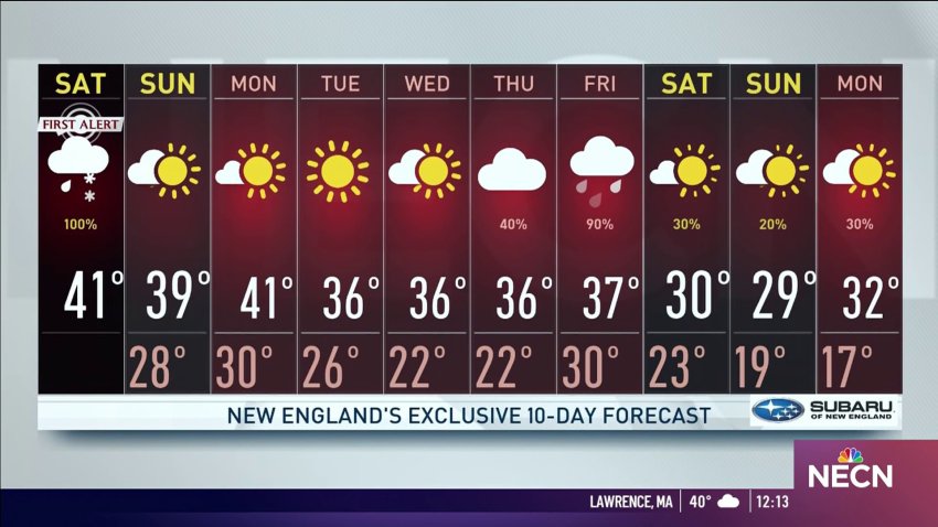
Rainy weekend in New England
Today: Increasing AM clouds, afternoon rain. Highs upper 40s. Overnight Tonight: Rain, few moderate burst, breezy, some patchy fog. Lows low to mid 40s. Sunday: Few AM showers, lots of PM clouds, lingering drizzle coast. Highs low to mid 50s inland, upper 40s coast.
-
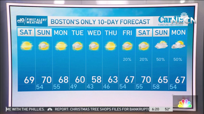
Sunny Skies and Temperatures Around the 70s on Saturday
Saturday: Highs around 70°, mostly sunny skies. Breezy nw winds 10-20 mph. Sunday: Sunny start, some afternoon clouds. Highs around 70. Light nw wind.
-
Chilly Night in New England
Tonight: Lows in the upper 30s to lower 40s. Light west wind. Mostly clear skies. Tomorrow: Sunny AM, few clouds PM, highs in the 60s. Light West, and Southwest breeze. Friday: Mostly sunny, winds turn Northeast near the coast. Near 60, by the water, 70’s well inland.
-
Lows Around the 50s in New England Tonight
Overnight Tonight: Partly cloudy and quiet. Lows around 50°. Thursday: Summer-like warmth with sun. Highs in the 80s. Friday: mostly sunny, very mild. Highs around 80, but dropping late in the day.
-
Rainy Days During The Week in New England
Today: sunny, breezy, NW gusts up to 30 mph, highs in the mid-40s, wind chills in the 30s. Tonight: clear, lows in upper 20s, NW wind becoming light and switching out of west. Tomorrow: mostly sunny, highs in the mid 50s, south wind gusting up to 15-20 mph.
-
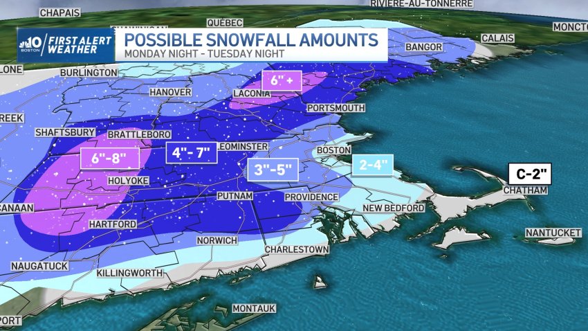
Updated Snowfall Totals for Tuesday's Big Winter Storm
It was a quintessential winter morning in New England with snow-covered grounds, chilly temperatures and a cloud/sun battle on Sunday. Clouds won and they remain through this evening keeping us with a chance of more scattered snow showers this afternoon exiting this evening. While not everyone gets to enjoy today’s flurries, there’s a more widespread storm bringing accumulating amounts...
-
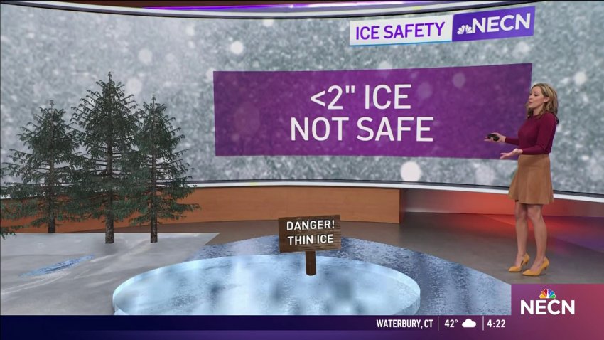
Light Snow Could Lead to Slick Road Conditions Saturday Evening
Tonight, light snow continues on and off, with little or no accumulation. Temperatures tonight (Saturday) will reach lows of 30, which might cause wet roads to freeze. Tomorrow (Sunday), more light snow is expected east of I-495, with as much as 4″ of snow arriving along the shore.
-
Chilly Sunday for Northern New England
Tonight: Gradually increasing clouds. Lows in the 20s, 30s on Cape Cod. Monday: Chance of snow/rain showers across southeast MA through early afternoon. A few coatings possible on the grass. Highs in the low 40s.
-
Cooler Air Through New England This Evening
Today: sun fades to high clouds, cooler. Highs in the lower 40’s. Tonight: clearing skies, seasonable chill, lows middle and upper 20’s. Colder in areas with snow cover. Sunday: mostly sunny, cooler. Highs in the upper 30’s.
-
Cloudy and Drizzly Thursday Makes Way for Light Snow on Friday
This Evening: Patchy showers, drizzle. Northern New England light icing & snow. Temps in the upper 30s. Overnight Thursday Night: Cloudy. Lows in the 30s. Friday: Periodic snow and rain, accumulations generally a coating to 2″ in snow areas. Highs in the 30s.
-
Partly Cloudy on Sunday for New England
This Evening: Temps in the 40s, partly cloudy. Overnight Sunday Night: Partly cloudy, colder. Lows in the mid 30s. Monday: Mostly sunny. Highs around 50. Tuesday: Mostly cloudy, pm rain. Highs in the 50s.
-
Mild Air Continues to Start The Year
New Year’s Day Today (Sunday): Partly cloudy, patchy fog. Sun breaks out, breezy. Highs in the 50s, 40s north. Overnight Sunday Night: Partly cloudy, colder. Lows in the mid 30s. Monday: Mostly sunny. Highs around 50.
-
The Air Will Stay Mild to Begin 2023
This Evening: Scattered rain. Highs in the low 50s. Overnight Saturday Night: Scattered showers. Temps around 50 at midnight. Lows in the 40s, developing fog. New Year’s Day Sunday: Early showers, patchy fog, sun breaks out, breezy. Highs in the 50s, 40s north. Monday: Mostly sunny. Highs around 50.
-

Warming Trend Continues on Friday in New England
This Evening: Mostly clear. Temps in the 40s. Overnight Thursday Night: Mostly clear. Lows in the 30s. Friday: Sun to increasing clouds, mild. Highs in the 50s. Saturday: Cloudy, sct’d showers to more widespread rain at night. Highs in the mid 50s.
-
New England Awaits Storm on Friday
Today (Tuesday): Bright sky, cool AM breeze. Highs 35-40°, wind chill 30°. Overnight Tuesday Night: Mostly clear except some immediate coastal cloud pockets. Lows in the 20s, 10s north. Wednesday: Sun & clouds, quiet air. Highs near 40°.
-
Mostly Sunny, Breezy Morning in New England
Today (Tuesday): Bright sky, cool AM breeze. Highs 35-40°, wind chill 30°. Overnight Tuesday Night: Mostly clear except some immediate coastal cloud pockets. Lows in the 20s, 10s north. Wednesday: Sun & clouds, quiet air. Highs near 40°.
-
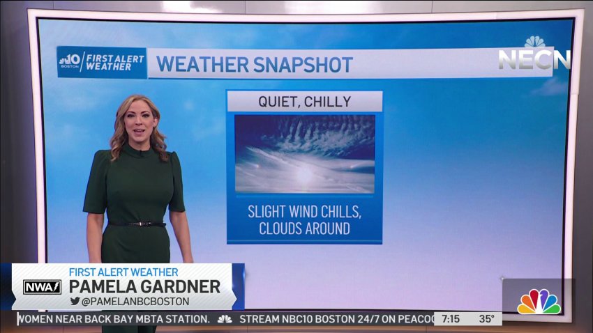
Quiet and Chilly Sunday in New England
Today (Sunday): Mostly sunny, late clouds. Highs in the upper 30s. Slight breeze makes wind chills in the upper 20s. Overnight Sunday Night: Mostly clear. Lows in the mid 20s. Monday: Sunny, chilly, breezy. Highs in the low 40s.
-
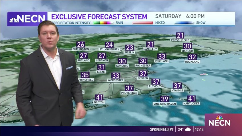
Clear, Chilly Saturday Night in New England
Clouds give way to partial clearing, as temperatures top out in the lower 40’s for the rest of the afternoon.
-
Bright, Brisk and Breezy on Friday for New England
Tonight: Clear and cool. Lows in the 20s. Friday: Bright, brisk, breezy. Highs in the 40s. Saturday: Cloudy and cool. Highs near 40°.
-
Soggy Saturday Makes Way for Sunny Sunday
We’re having a split weekend; today is mild and soggy while Sunday brings cooler temperatures & sunny skies.
Trending
