
-
Forecast: Plenty of sunshine on Labor Day
Tonight: Few clouds then developing fog near sunrise at the coast. Lows in the mid to upper 60s. Labor Day: Early fog near the coast, bright afternoon, highs in the low 80s east to upper 80s inland.
-
Forecast: Stray showers overnight into Sunday
Tonight: Partly to mostly cloudy and mild. Patchy fog possible. Low in the mid 60s. Sunday: Morning clouds then partly cloudy. A few stray showers or storms possible. High in the low to mid 70s. Monday: Partly cloudy. High in the low to mid 70s
-
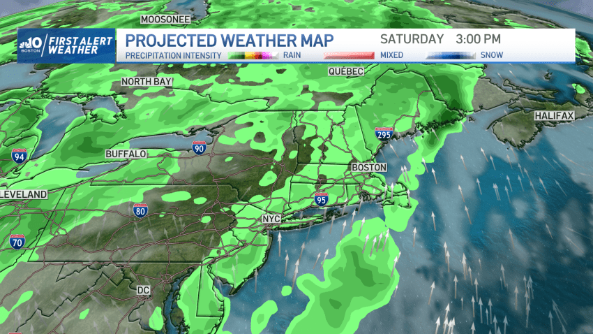
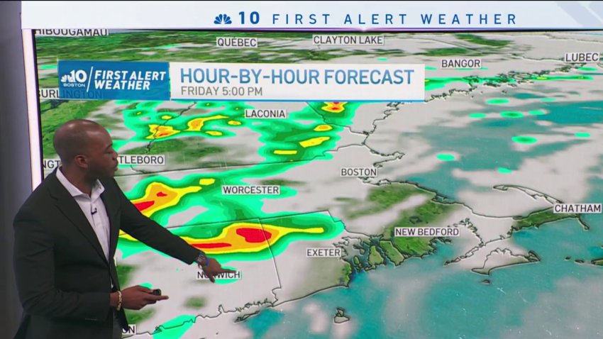
Forecast: Rain returns with possible isolated thunderstorms
Overnight Tonight: Increasing clouds. Lows in the 60s. Monday: Showers arrive mid to late morning. Afternoon and evening downpours, embedded thunder possible. Highs in the 70s. Tuesday: Scattered thunder, isolated damaging storms. Highs around 80.
-
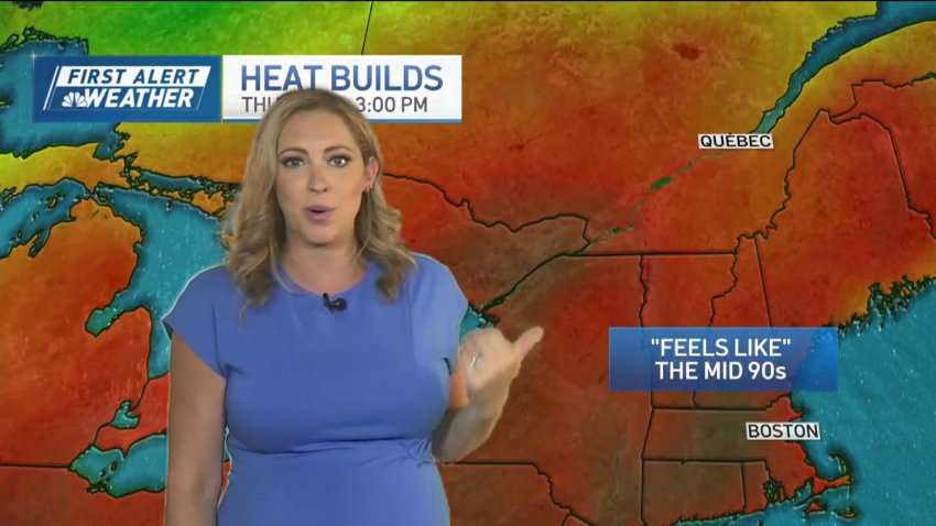
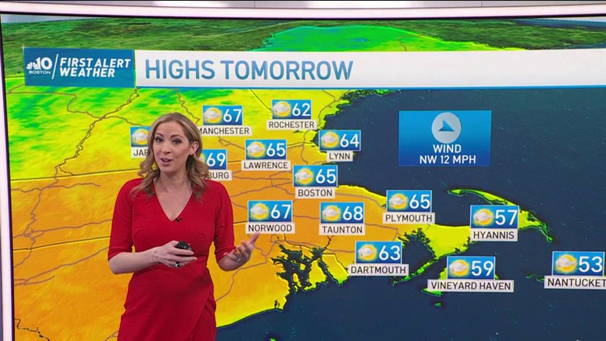
FORECAST: Temps reach extreme heat before rain
Today (Wednesday): Sunny, humid, isolated storm late. Highs around 90. Overnight: Mostly cloudy, patchy fog. Lows in the upper 60s. Thursday: Mostly cloudy, scattered pm showers or storms. Highs in the upper 80s. Friday: Scattered showers and strong storms. Highs in the low 80s.
-
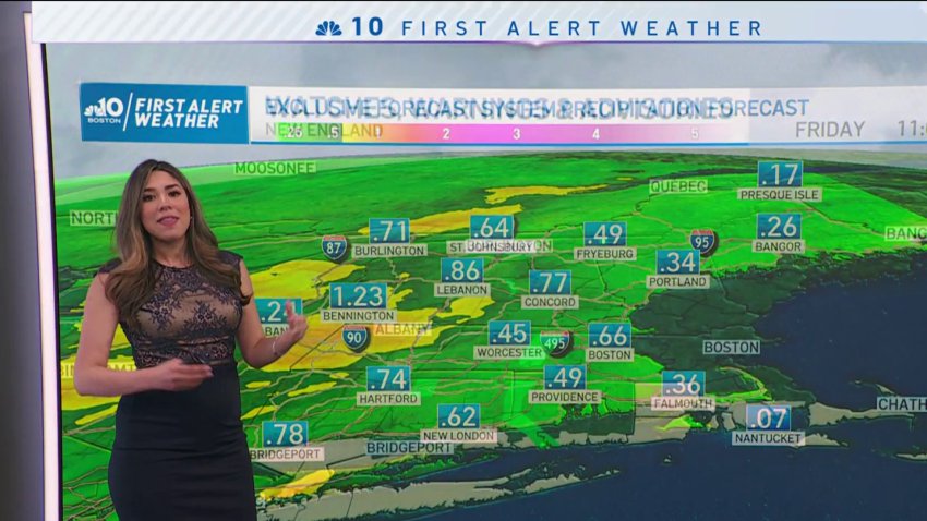
More heavy rain possible this week for flood-hit New England
Scorching heat takes us to the 90s today along with bright skies and high humidity. Isolated downpours and embedded thunder is possible across northern and western New England today. Severe thunderstorm warnings were issued in parts of Maine and western Massachusetts Wednesday afternoon, but they have since expired. Click here to see active weather alerts. More impactful precipitation, however, is…
-

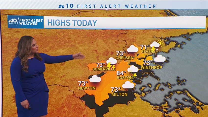
Today's a scorcher! Temperatures to hit 90s, rain threat still looms
A bona fide summer scorcher is on hand today. The setup keeps the sea breezes at bay (literally), and the sun glares overhead. Boston has the chance to hit 90 for the first time this season! That’s saying something in this somewhat muted warm season. Heat indices will soar as well. We’re seeing the combination of high temps and...
-
FORECAST: Temps to hit 90s
Wednesday: Sunny, highs in the 80s, 90s inland. Thursday: Mostly cloudy, scattered pm showers or storms inland. Highs in the low 80s.
-
FORECAST: Scattered thunderstorms to clear by evening fireworks
Today (Tuesday, July 4th): AM showers, PM rain & thunder, quieting by fireworks with patchy coastal fog. Highs in the 70s, humid. Overnight Tonight: Variable clouds, patchy coastal fog. Lows in the 60s. Wednesday & Thursday: Fair sky, chance isolated late thunder. Highs in the 80s.
-
Forecast: More Rain Closes Out the Weekend
Overnight: Lows in the mid-40s inland, upper 40s Boston & coast. Cloudy, drizzly. Sunday: Highs in the lower 50s, cloudy/drizzly AM, PM showers. Gusting near 30 mph. Monday: Highs in the 60s, cloudy, few showers around.
-
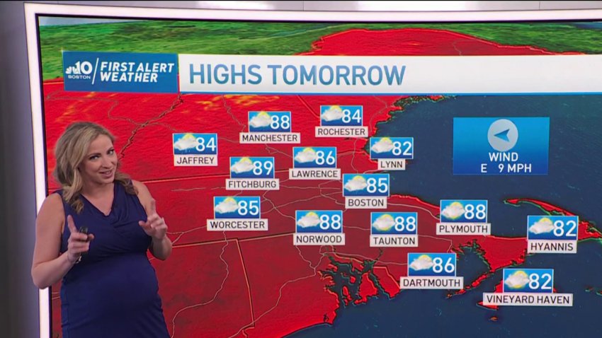
FORECAST: Near Record Heat Before Rain Moves In
Today (Thursday): Sunny with summer warmth. Highs in the 90s inland, 80s at the coast with a sea breeze. Overnight Tonight: Mostly clear, patchy South Coast fog. Lows in the 60s. Friday: Sun & building clouds to scattered PM thunder. Highs in the 90s inland, 80s coast.
-
Sunny and Breezy Sunday in New England
We got an astonishing amount of rain with Saturday’s event in parts of southern New England. Attleboro recorded up to 4” and 3.5” in parts of Rhode Island. Coastal Maine also had a decent amount of rain which is helping us battle the abnormally dry conditions we’ve had up to this season. For your Sunday afternoon you’ll keep enjoying...
-
Clear and Sunny Sunday in New England
Clouds quickly part for sunshine on Sunday. With a high May sun angle, high temperatures are well into the 70’s, with a bit of breeze from the West. Monday is sunny, but much cooler, with windy conditions. High temperatures only in the lower and middle 60’s. Tuesday is mostly sunny and pleasant, with high temperatures in the middle 60’s. Look…
-
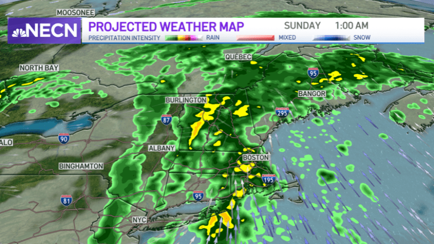
Downpours Continuing in New England, Clearing Sunday Morning
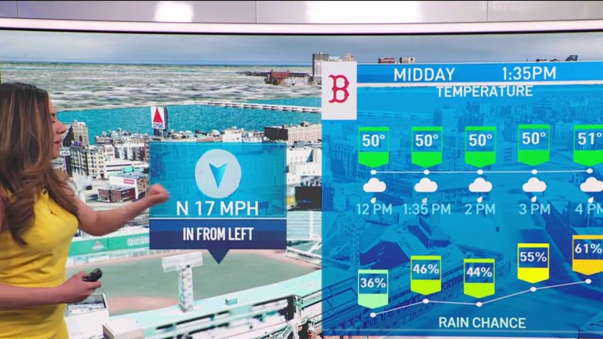
It’s a split forecast this weekend with wind and rain Saturday afternoon turning milder and drier Sunday. Temperatures this Saturday stay in the 60s, showers move steadily northward spreading from the south coast this morning to northern Maine this afternoon/evening. While the start of it is light, heavier rain may come in at times this afternoon/evening and another round...
-
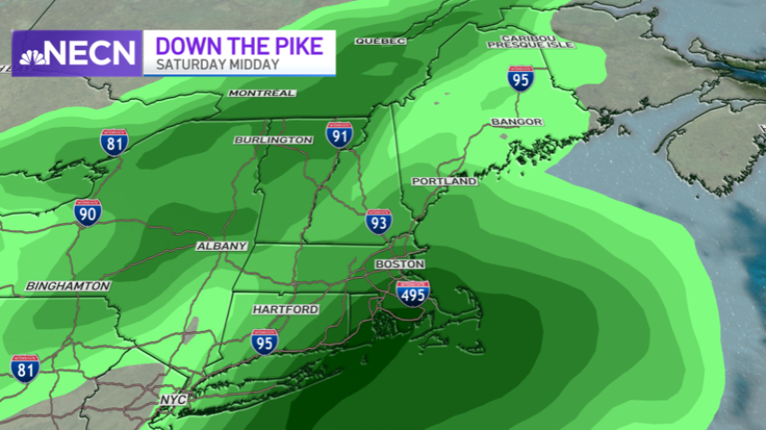
Rainy Weekend Before Period of Dry Weather Next Week
The weekend is upon us, and the forecast is split. We’re giving up most of the day to wet weather, but it’s an important deposit in the rain bank to sustain us through another long period of dry weather next week. By itself, the approaching front from the west isn’t much, but combined with a meandering low pressure system...
-
Rain, Strong Winds Move Through Region Saturday
We wrapped up our work week with bright skies and inland temperatures in the 70s on Friday. Showers are knocking on our door front as we anticipate the arrival of a coastal low. While much of northern New England will see amounts ranging from ¼ to ¾ of an inch, southern New England may wind up with over 2 inches…
-
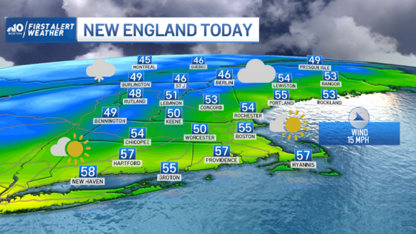
Region Wakes Up to Frost, Cold Air to Linger
A cold start to Thursday, with widespread freezing conditions likely. However, with the strong May sunshine, temperatures quickly climb to the lower and middle 60s across the majority of New England. Friday is milder, with bright sunshine, and highs in the lower 70s.. Clouds arrive for Saturday, and eventually beneficial rain. However, the rain doesn’t arrive until later in...
-
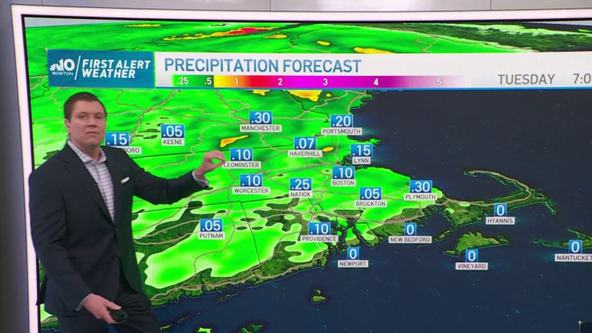
Forecast: Scattered Showers Throughout the Week
Tonight: Rain tapers off, partly cloudy skies, lows in the Tomorrow: Spotty showers, highs in the low 50s. NE wind. Tuesday: on and off rain showers, cool NE wind. Highs in the middle 50’s.
-

Forecast: Sunny Skies Through End of the Week
Today (Thursday): Mostly sunny. Highs in the 60s, late day seabreeze. Tonight: Partly cloudy. Lows in the upper 30s. Tomorrow: Mostly sunny. Highs in the 60s inland, 50s at the coast.
-
Clear, Breezy Day Before Warmer Weather Moves In
An upper level low is spinning to our north and continues to influence our weather for another day. This means that there is a cool pool of air aloft over New England and we will see the clouds thicken up, along with a few spot showers in the north country, to sprinkles. Then by sunset the clouds thin out...
-
Forecast: Temperatures Increase Through End of Week
Wednesday: Mostly sunny, breezy. Highs in the upper 50s.
Trending
