
By Tuesday afternoon, it's going to be 55 degrees.
How does this happen? It's called high amplitude flow.
Last week, a parcel of air released from north pole, passing through the eastern United States. It was piece of the polar vortex, and slid across New England Saturday night and Sunday. The coldest reading in New England was 40 below zero on top of Mount Washington. We have another sub zero morning Monday, but this time without dangerous wind chills. Polar high-pressure system that moved in Sunday pushes off to our south during the day Monday, causing warmer air to move in from the south.
As were were so cold, the southwest has been very warm.
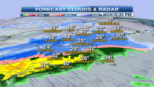
Record high temperature in the 80s and 90s was experienced in California and Arizona the last several days. Along the boundary between the cold that is moving out, and the warmth that is on the way in, there is a band of snow, ice, and rain arriving in New England late Monday.
Fading sunshine is here for early in the day, with temperatures rebounding to the 20s to lower 30s.
Local


Snow arrives in Connecticut just before sunset, advancing into Rhode Island and Massachusetts, becoming moderate to heavy for a short time between 5 and 8 p.m.
One to three inches of snow are possible before a change to rain by midnight.
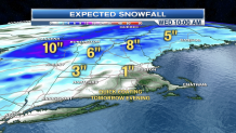
Snow continues advancing into Vermont, New Hampshire and Maine, also with one to three inches expected before changing to ice and rain early Tuesday. The mountain areas may get more like five to seven inches of snow before the change.
Powerful low-pressure will be intensifying over the state of Pennsylvania moving up the Hudson river valley during the day Tuesday.
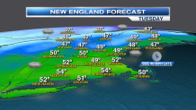
This storm track means much warmer weather here with high temperature in the 50s Tuesday in southern and eastern New England.
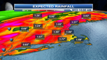
Rain will shut off for a time Tuesday morning for southern New England, before returning and becoming heavy in the afternoon and evening.
Further north in the mountains, snow will change to a period of ice and then rain midday Tuesday.
The intensifying storm center passes near Montreal Tuesday night, at that time we have downpours and wind from the south, then west, gusting 40 to 50 mph, especially strong near the shore.
Rain will change back to snow before ending in the mountains late Tuesday night and early Wednesday.
One to two inches of rain are expected before ending late Tuesday night.
After a very windy start on Wednesday, we should dry out with a good amount of sunshine and high temperature once again well into the 40s to near 50 across southern New England.
Thursday looks quiet. Then another fairly strong storm moves from Ontario into northern New England Friday. That also brings a mix of snow and rain to central and northern New England Friday night and early Saturday.
Seasonably cold weather and drying is expected for next Sunday.
