
Saturday night will be clear with a big bright moon, low temperatures in the 10s and 20s. Spring begins Sunday, with the coldest weather we've had in a while.
The sky will start off sunny, with increasing clouds for southern New England. High temperature in the 20s and 30s north, 30s to low 40s south.
Our St. Patrick's Day parade's should be dry, although a snow flurry is not out of the question.
The wind will be coming in off of the ocean, from the Northeast 10 to 20 mph, it is winter jacket weather for our Sunday parades.
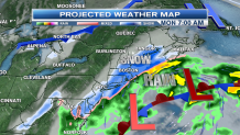
The weather map tonight shows several distinct features.
In New England, we have a cold, dry flow, thanks to an upper level low over the Canadian Maritime provinces. That is the upper low that brought hail and rainbows on Thursday and Friday. Now, we are on the backside of that low with polar dry air bringing sunshine and colder air.
This polar stream will keep a system moving off the mid-Atlantic states off to our south tonight.
But there is plenty of energy left behind - enough energy to generate another low pressure system on the tail of the first.
Local


So as one storm misses overnight and Sunday, another low may bring significant snow to eastern New England before sunrise on Monday.
High up in the sky, in the jet stream, we are tracking a cold upper low pressure system cut off over the central plains states.
The interaction of that low, slowly moving toward the east coast, plays a major role in the track of the second low pressure system tracking southeast of Nantucket Monday. There will still be a major storm, but where?
The latest thinking is Newfoundland and Labrador may get a blizzard Monday night and Tuesday. But the storm is only in it's early stages of intensification for us.
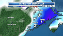
Here in New England, the storm will be strengthening as it tracks 50 to 100 miles east of Cape Cod Monday noon. This track and intensification will result in a band of moderate to heavy snow along I-95 in eastern New England during the Monday morning commute, we may expect delays and cancellations. Wind should not be strong enough to cause major problems. But this time of year, we tend to get exceptionally dense wet snow, so some scattered power outages are possible.
Snowfall amounts will likely range from four to seven inches closer to the coast, with one to three inches on the east side of the Connecticut and Merrimack River Valleys. Another challenge is whether or not Cape Cod stays all snow, or changes back and forth between snow and rain, that's why we are keeping amounts of one to three inches here. The Cape and Island's gets the most wind though, from the northeast, then northwest 20-30 mph with stronger gusts.
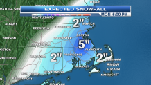
Timing of the snow looks like 9 p.m. Sunday to 7 a.m. Monday for Connecticut and Rhode Island, midnight to 11 a.m. for Massachusetts and southeastern New Hampshire, and into Monday afternoon along the Maine coast.
Monday night looks clear and cold with any slushy sidewalks turning icy to start Tuesday.
Clouds increase on Tuesday as a warm front approaches from the west. There is a chance of a period of rain and snow late in the day or in the evening especially in central and northern New England. Highs Tuesday in the 40s.
Wednesday starts off gray, with increasing sunshine and a high temperature near 50 degrees.
Late week looks warmer, with the threat for rain returning by later Friday, high temperature should be in the 60s by Friday.
