
The Arctic air has arrived and our temperatures keep crashing down this Friday afternoon. Our warmest temperatures already happened this morning, we’re now watching the thermometer going below 0 in northern New England with wind chills 30 degrees below.
The thing is, our coldest air will take over tonight and into the early morning hours Saturday. Our temperatures will begin the coldest on Saturday morning and slowly subside to the single digits by the evening hours. The sun is out, but that doesn’t help — temperatures remain feeling 25-50 degrees below 0 across New England. With no doubt, temperatures are the coldest north of the Merrimack Valley and the Monadnock Region.
Wind will also grow gusting from 30-50 mph as the day progresses. The strongest wind gusts will take place in Cape Cod and the southeast this evening and early tonight. While the wind slowly winds down overnight in the south, temperatures will remain the coldest through 7 a.m.
Get New England news, weather forecasts and entertainment stories to your inbox. Sign up for NECN newsletters.

The early afternoon on Saturday keeps our wind chills 20 degrees below. If you can prevent the outdoors, it’s best to stay. Hydrate, dress in layers, monitor the space heaters and keep electronics charged. Because of the wind, some areas may experience outages. Having enough of the alternative heating source will help if your residence is one of the affected. Information on warm shelters are available in our NBC10 Boston’s Website for those in need.
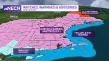
Blizzard warnings are in effect over Aroostook County, Maine due to blowing snow; visibility below a quarter of a mile may continue through Saturday evening. Wind chill warnings expand over 95% of New England.
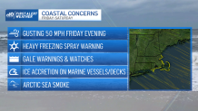
Freezing spray warnings are also in effect along the seaboard from Maine to Long Island due 4 p.m. Saturday. Wind gusts of 45-50 mph are expected and seas 7-10 feet, heavy freezing spray, any may rapidly accumulate on vessels.
Weather Stories

Mother Nature will bring us back to milder temperatures by Sunday, wind chills may still remain in the 30s in the warmest part of the day. Next week keeps us in the mild trend of 40s through the end of our Exclusive 10-day forecast. Stay safe.
