
New England’s weather turned a corner Thursday morning, as the slow-moving storm that had been sitting off the Jersey Shore for days on end — a product of a lingering piece of atmospheric energy left behind from former Hurricane Ian — shifts east and over the ocean, allowing drier air and splendid weather from the northwest to drift into New England.
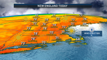
Thursday morning saw clouds breaking from northwest to southeast, last to clear from Cape Cod, and Thursday afternoon temperatures will correspond to how much sun any given community sees, with northwestern New England mildest, breaking 75 degrees. A northerly wind becoming light and variable will allow for some afternoon sea breezes that will keep immediate coastal locales, especially Cape Cod, where sun is a bit more sluggish to emerge, cooler and in the 60s.
Clouds return for a time overnight Thursday night as another weak push of even milder air moves into New England from the southwest, prompting a predawn Friday shower for some but opening the door to a Friday southwest breeze for all, teaming with daytime sun to bump temperatures into the middle 70s for many New England towns.
Get New England news, weather forecasts and entertainment stories to your inbox. Sign up for NECN newsletters.
In October, it’s rare to see temperatures in the 70s last, and this fling will be no exception with a quick-moving cold front arriving Friday afternoon to evening, northwest to southeast, respectively, delivering scattered showers and even a thunderstorm as it shifts the wind to blow from the northwest by Friday night.
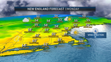
The new wind delivers new air for the weekend, with daytime high temperatures both Saturday and Sunday only in the 50s to near 60 degrees for many, but the cool Canadian air is also dry air, which means both weekend days are expected to be bright and dry. The only weekend exception to dry weather will be across leaf peeping country of the far north, where a Sunday afternoon disturbance aloft will deliver some building, puffy cumulus clouds for a scattered afternoon mountain rain showers.
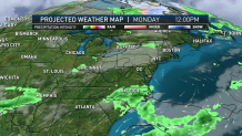
Next week brings air very close to or perhaps just slightly cooler than normal when averaged over the week, with shower chances likely to be limited to days when energetic, jet stream disturbances traverse overhead, specifically on Monday and perhaps again toward the end of the week, with the early call on next Saturday looking good from our vantage point 10 days out.
