
By now you’ve seen headlines of the ongoing frost and freeze across the Central US and Deep South. An anomalously cold push of air dropped all the way down to I-10. Birmingham, Alabama dropped to 32 degrees for the first time this season before Billings, Montana! Freeze Watches are possible for North Florida and the Panhandle.
That same system was responsible for showers and thunderstorms across New England earlier in the week, but the air mass is, in a sense, modified and won’t bring the core of the cold air to us.
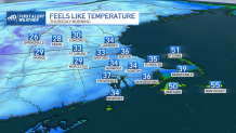
However, the next couple of mornings will be cold enough to produce patchy frost across New England, specifically in suburban areas and low-lying valleys.
Get New England news, weather forecasts and entertainment stories to your inbox. Sign up for NECN newsletters.
Thursday morning lows are slightly above freezing. While leafy and hardy greens should do fine, it’s important to cover up annuals and sensitive vegetation, or bring the pumpkin indoors if it’s in an outside display. Because of the dramatic drop in temperatures, tire pressure lights may come on, signaling low tire pressure. This happens when air molecules slow down, and contract with lower temperatures. A 10° drop in temperatures can lead to a 1-3 PSI reduction in tire pressure.
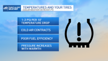
According to the US Department of Energy, underinflated tires reduce gas mileage by .2% for every drop in PSI.
Weather Stories


If you’re tired of the cold, it looks temporary. Next week brings about a coastal low that will likely bring increased cloud coverage, and periods of rain through much of the week.
