
After a solid dose of rain – and mild temps to boot – we’re returning to sun Thursday. A steady northwest wind will keep it bright through the day, but it also promises to bring the temps down later in the afternoon.
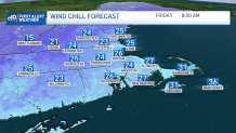
Colder air is shuffling in, and we’ll feel the bite late Thursday night and much of the weekend. Dewpoints will also fall into the “chapped lips” range as a super dry airmass works in. The combination of that and a steady breeze on Friday will make it feel like mid-20s in the morning. While the afternoon recovers to the low and mid-40s, it will still only feel like mid and upper 30s.
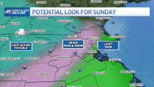
The tricky part of the forecast comes over the weekend. We’re solidly in the clouds, and with northeast winds, we could possibly see a few light showers (or sprinkles) pop up along the coast or even as far back as Metrowest. This should be the limit to the damp weather on Saturday. With a weakening storm system sliding in on Sunday, we’ll continue with the cloud theme, but also include the possibility of snow showers over the Worcester Hills. This shouldn’t amount to much (if any) accumulation as the weather system could completely unravel before it even makes it to central Massachusetts. Elsewhere, a sprinkle or flurry is possible as highs only make it back to the mid and upper 30s.
Get New England news, weather forecasts and entertainment stories to your inbox. Sign up for NECN newsletters.
We’ll shake the clouds and go for more sun early next week. Another storm system will be rolling our way by Thursday, and signs (again) point to rain.
